School nearby Quick learners
Sri Lanka
School nearby Quick learners
Quick learners
948 Marawila - Nattandiya Rd, Marawila 61210, Marawila - Nattandiya Road, 61210, Marawila, Puttalam, LK Sri Lanka
contacts phone
:
+94
Latitude:
7.4130655
, Longitude:
79.8315648
larger map & directions
read more
nearest School
284 m
St. Xavier's Central College
A3, Marawila
School
read more
530 m
Holy Family Convent
Marawila
School
read more
702 m
මාරවිල කතෝලික කනිෂ්ඨ පිරිමි විදුහල
Marawila
School
read more
714 m
St. Mary's Boys School (SMC)
Marawila
School
read more
1.265 km
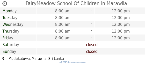
FairyMeadow School Of Children
Mudukatuwa, Marawila
School
read more
1.495 km
Success Institute Japanese Language School
Marawila - Nattandiya Road, Weerahena
School
read more
1.545 km
St.Fathima Roman Catholic School
Mudukatuwa, Marawila
School
read more
1.606 km
Surangana Preschool
Chilaw - Colombo Main Road, Marawila
School
read more
1.893 km
Mumanadamma Vidrelaya
Marawila
School
read more
1.898 km
Sumana Damma School
Marawila
School
read more
1.912 km
Sumanadhamma Maha Vidyalaya
Marawila
School
read more
2.11 km
Haththiniya Vidyalaya
Marawila
School
read more
2.132 km
AMW Piyaseeli
Nattandiya
School
read more
2.137 km
හත්තිනිය කනිෂ්ඨ විද්යාලය
Haththiniya, Marawila
School
read more
2.154 km
Haththiniya Primary College
Marawila
School
read more
2.191 km
St.Theresa Catholic School
Mahawewa
School
read more
2.527 km
Halpanwila Government School
Walahapitiya Road, Marawila
School
read more
2.543 km
Sri Maha Mahinda Dhamma school
Mawila Road, Nattandiya
School
read more
2.927 km
Dhammissara National College
Nattandiya
School
read more
3.175 km
Nath/Mawila Jayalath matha school
Mawila Road, Nattandiya
School
read more
3.348 km
Mawila
Sri Lanka
School
read more
3.447 km
C/H Nattandiya Zahira Muslim Vidyalaya
Nattandiya
School
read more
3.67 km
Thalawilawella Junior School - Thoduwawa
Sri Lanka
School
read more
3.785 km
Dharmaraja College
Walahapitiya
School
read more
3.833 km
Thummodara School
Sri Lanka
School
read more
📑
all categories
Accounting
Administrative area level 1
Administrative area level 2
Airport
Amusement park
Aquarium
Art gallery
Atm
Bakery
Bank
Bar
Beauty salon
Bicycle store
Book store
Bowling alley
Bus station
Cafe
Campground
Car dealer
Car rental
Car repair
Car wash
Casino
Cemetery
Church
City hall
Clothing store
Colloquial area
Convenience store
Country
Courthouse
Dentist
Department store
Doctor
Electrician
Electronics store
Embassy
Finance
Fire station
Florist
Food
Funeral home
Furniture store
Gas station
General contractor
Grocery or supermarket
Gym
Hair care
Hardware store
Health
Hindu Temple
Home goods store
Hospital
Insurance agency
Intersection
Jewelry store
Laundry
Lawyer
Library
Light rail station
Liquor store
Local government office
Locality
Locksmith
Lodging
Meal delivery
Meal takeaway
Mosque
Movie rental
Movie theater
Moving company
Museum
Natural feature
Neighborhood
Night club
Painter
Park
Parking
Pet store
Pharmacy
Physiotherapist
Place of worship
Plumber
Point of interest
Police
Political
Post office
Premise
Real estate agency
Restaurant
Roofing contractor
Route
Rv park, camping
School
Shoe store
Shopping mall
Spa
Stadium
Storage
Store
Subpremise
Supermarket
Synagogue
Taxi stand
Train station
Transit station
Travel agency
University
Veterinary care
Zoo
administrative area level 3
sublocality level 1
sublocality level 2
↑