School nearby Siri Vijaya Dham Pasala
Sri Lanka
School nearby Siri Vijaya Dham Pasala
Siri Vijaya Dham Pasala
Sri Lanka
contacts phone
:
+94
Latitude:
6.0525772
, Longitude:
80.3721491
larger map & directions
read more
nearest School
582 m
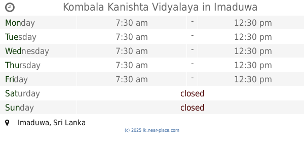
Kombala Kanishta Vidyalaya
Imaduwa
School
read more
612 m
Kobala kanishta vidyalaya
Sri Lanka
School
read more
1.808 km
Walpola Gunathilaka Kanishta Vidyalaya
Walpola Imaduwa
School
read more
2.094 km
Gunathilaka Vidyalaya
Sri Lanka
School
read more
2.108 km
Batemulla National College
Imaduwa
School
read more
2.137 km
DAHARA EARLY CHILD DEVELOPMENT CENTER
A17, Imaduwa
School
read more
2.15 km
ඉමදුව නාලන්දා ප්රාථමික විද්යාලය
Imaduwa
School
read more
2.354 km
Wimansa Institute
Imaduwa
School
read more
2.395 km
Wathawana Primary School
Imaduwa
School
read more
2.5 km
Dahare Pre School
A17, Imaduwa
School
read more
2.5 km
Dahare Pre School
Galle-Deniyaya-Madampe Highway, Imaduwa
School
read more
3.535 km
Howpe Maha Vidyalaya
Howpe Mawella Road, Howpe
School
read more
3.621 km
Mawella K.V.
Sri Lanka
School
read more
3.807 km
Imaduwa VTC
Diwelagoda,Imaduwa
School
read more
3.876 km
Dikkumbura Maha Vidyalaya
Sri Lanka
School
read more
3.925 km
Dikkumbura Sri Siddhartha Maha Vidyalaya
Imaduwa Road, Ahangama
School
read more
4.017 km
Pushpa English academy
Galle
School
read more
4.22 km
Andugoda K.V.
dikkumbura
School
read more
4.253 km
Dikkumbura K.V.
Ahangama
School
read more
4.437 km
Kananke Junior Model School
Kananke
School
read more
4.477 km
MR/ Kananke Adarsha Kanishta Vidyalaya
Matara
School
read more
4.673 km
Thiththagalla Atanikitha College
Ahangama Ampawila Road, Ahangama
School
read more
4.717 km
Polpagoda Dharmapala Maha Vidyalaya
Polpagoda Vidyalaya, Yakkalamulla
School
read more
5.365 km
Horadugoda Primary College
Matara
School
read more
5.889 km
Siri Wimalasiri Kanishta Vidyalaya
Ahangama
School
read more
📑
all categories
Accounting
Administrative area level 1
Administrative area level 2
Airport
Amusement park
Aquarium
Art gallery
Atm
Bakery
Bank
Bar
Beauty salon
Bicycle store
Book store
Bowling alley
Bus station
Cafe
Campground
Car dealer
Car rental
Car repair
Car wash
Casino
Cemetery
Church
City hall
Clothing store
Colloquial area
Convenience store
Country
Courthouse
Dentist
Department store
Doctor
Electrician
Electronics store
Embassy
Finance
Fire station
Florist
Food
Funeral home
Furniture store
Gas station
General contractor
Grocery or supermarket
Gym
Hair care
Hardware store
Health
Hindu Temple
Home goods store
Hospital
Insurance agency
Intersection
Jewelry store
Laundry
Lawyer
Library
Light rail station
Liquor store
Local government office
Locality
Locksmith
Lodging
Meal delivery
Meal takeaway
Mosque
Movie rental
Movie theater
Moving company
Museum
Natural feature
Neighborhood
Night club
Painter
Park
Parking
Pet store
Pharmacy
Physiotherapist
Place of worship
Plumber
Point of interest
Police
Political
Post office
Premise
Real estate agency
Restaurant
Roofing contractor
Route
Rv park, camping
School
Shoe store
Shopping mall
Spa
Stadium
Storage
Store
Subpremise
Supermarket
Synagogue
Taxi stand
Train station
Transit station
Travel agency
University
Veterinary care
Zoo
administrative area level 3
sublocality level 1
sublocality level 2
↑