School nearby Smi Vocational Training Institute
Sri Lanka
School nearby Smi Vocational Training Institute
Smi Vocational Training Institute
237, Colombo Road, ගම්පහ, ගම්පහ, LK Sri Lanka
contacts phone
:
+94 70 230 3030
Latitude:
7.0899472
, Longitude:
80.0033738
larger map & directions
read more
nearest School
37 m
The IT Workshop
No. 344/1, ColomboRoad, Gampaha
School
read more
198 m
Swarnapali Balika Vidyalaya
Weera Mawatha, Gampaha
School
read more
259 m
Ratnawali Balika Maha Vidyalaya Ground
Gampaha
School
read more
304 m
Shilpa Education Institute
Minuwangoda-Gampaha-Miriswatta Road, Gampaha
School
read more
367 m
Bandaranayake College
Kalyani Road, Gampaha
School
read more
395 m
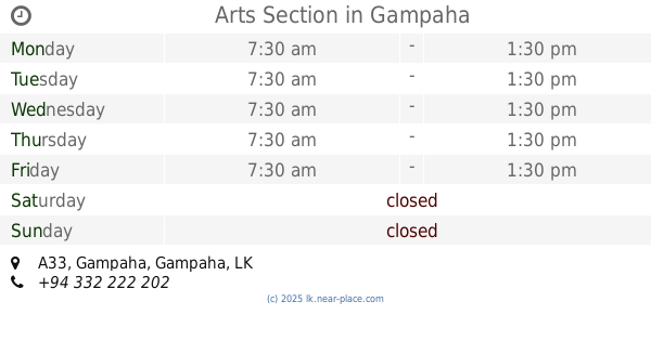
Arts Section
A33, Gampaha
School
read more
431 m
Bandaranayake Hall
Gampaha
School
read more
480 m
Yashodha Dancing Academy
Yakkala Road, Gampaha
School
read more
499 m
Siyapatha Educational Centre
Yakkala Road, Gampaha
School
read more
499 m
Holly Cross College
Gampaha
School
read more
520 m
Nimala Kumari Sewana
Holy Cross College,, ගම්පහ
School
read more
520 m
Holy Cross Girls School
Holy Cross College,, ගම්පහ
School
read more
520 m
Holy Cross College Gampaha
Gampaha
School
read more
521 m
JMC Gampaha
136 Yakkala Road, Gampaha
School
read more
524 m
Angile vision
Tissa Road, Gampaha
School
read more
610 m
Sandy Cake & Bake Academy
Room 141, 4Th Floor, Ward City, Gampaha
School
read more
658 m
Amaranath Ranatunga
49/1, Church Road, Gampaha
School
read more
666 m
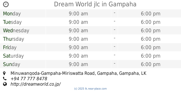
Dream World jlc
1, Minuwangoda-Gampaha-Miriswatta Road, Gampaha
School
read more
905 m
KidsIgnite
104/82, Sri Bodhi Road, Gampaha
School
read more
940 m
swiss lanka hotel school
16 Vilabada Road, Gampaha
School
read more
945 m
Weerasinghe Nursery School
71, Vijaya, Rd, Gampaha, Gampaha
School
read more
966 m
Sri Bodhi Primary School
Gampaha
School
read more
992 m
Gajaba School
Church Road, Gampaha
School
read more
1.021 km
Nanasala
Bendiyamulla East, Gampaha
School
read more
1.023 km
Gampaha Nenasala
Minuwangoda-Gampaha-Miriswatta Road, Gampaha
School
read more
📑
all categories
Accounting
Administrative area level 1
Administrative area level 2
Airport
Amusement park
Aquarium
Art gallery
Atm
Bakery
Bank
Bar
Beauty salon
Bicycle store
Book store
Bowling alley
Bus station
Cafe
Campground
Car dealer
Car rental
Car repair
Car wash
Casino
Cemetery
Church
City hall
Clothing store
Colloquial area
Convenience store
Country
Courthouse
Dentist
Department store
Doctor
Electrician
Electronics store
Embassy
Finance
Fire station
Florist
Food
Funeral home
Furniture store
Gas station
General contractor
Grocery or supermarket
Gym
Hair care
Hardware store
Health
Hindu Temple
Home goods store
Hospital
Insurance agency
Intersection
Jewelry store
Laundry
Lawyer
Library
Light rail station
Liquor store
Local government office
Locality
Locksmith
Lodging
Meal delivery
Meal takeaway
Mosque
Movie rental
Movie theater
Moving company
Museum
Natural feature
Neighborhood
Night club
Painter
Park
Parking
Pet store
Pharmacy
Physiotherapist
Place of worship
Plumber
Point of interest
Police
Political
Post office
Premise
Real estate agency
Restaurant
Roofing contractor
Route
Rv park, camping
School
Shoe store
Shopping mall
Spa
Stadium
Storage
Store
Subpremise
Supermarket
Synagogue
Taxi stand
Train station
Transit station
Travel agency
University
Veterinary care
Zoo
administrative area level 3
sublocality level 1
sublocality level 2
↑