School nearby St. Anthony's Pre School
Sri Lanka
School nearby St. Anthony's Pre School
St. Anthony's Pre School
Gampaha, Sri Lanka
contacts phone
:
+94 77 956 1555
Latitude:
7.022805
, Longitude:
79.9310725
larger map & directions
read more
nearest School
349 m
Eldorado Preschool
B13
School
read more
395 m
Risara Driving School
Gampaha
School
read more
493 m
Basilica College Ragama
Rehabiltation Hospital Road
School
read more
528 m
Great Eiensteins Montissori School
Sri Lanka
School
read more
568 m
Holy Angels Convent
Sri Lanka
School
read more
717 m
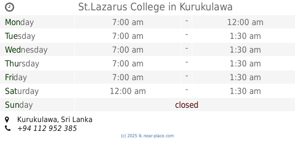
St.Lazarus College
Kurukulawa
School
read more
727 m
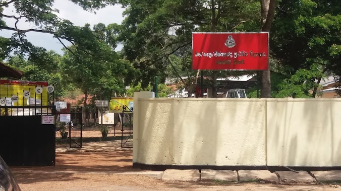
WE/KE/ St.Lazarus Vidyalaya Kurukulawa
Kurukulawa
School
read more
749 m
Oneki Preschool
Gampaha
School
read more
830 m
Preclinical Building Ground, Ragama Medical Faculty
Faculty of Medicine - University of Kelaniya, Annasihena Road, Ragama
School
read more
848 m
Bandaranayake (Primary) school, Horape.
Sri Lanka
School
read more
876 m
Heenkenda Primary College
Gampaha
School
read more
887 m
Bandaranayake Primary School
Horape Road, Ragama
School
read more
901 m
Scchchochol
Kurukulawa Road, Kurukulawa
School
read more
906 m
Sri Sangamittha Play Ground
Prison Road
School
read more
938 m
Sanghamiththa maha vidyalaya
Gampaha
School
read more
967 m
Ihalagama Sri Dharmarakshitha Primary School
Ragama
School
read more
1.049 km
Chapa Dance Studio
851.37a UDA Road, Ragama
School
read more
1.102 km
Mihidu Daham Pasala
Gampaha
School
read more
1.126 km
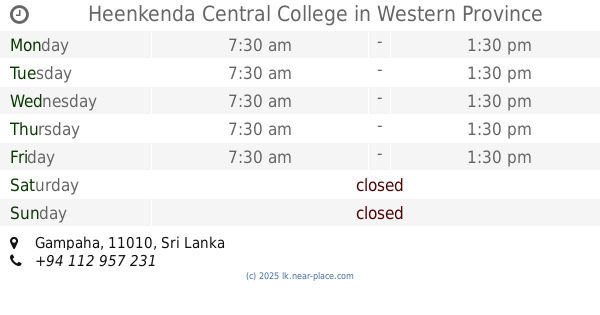
Heenkenda Central College
School
read more
1.295 km
We/ne/basilica Primery College
Ragama Road, Ragama
School
read more
1.419 km
Sri Yasodara Dhamma School
Kendaliyaddapaluwa, Galwala Road, Ragama
School
read more
1.525 km
Basilica Primary School Ragama බැසිලිකා ප්රාථමික විද්යාලය - රාගම
Ragama
School
read more
1.59 km
St. Peter and Paul Sunday School
Ragama
School
read more
1.91 km
Dharmaraja Vidyalaya (ධර්මරාජ විද්යාලය )
Mahara Nugegoda, Kadawatha
School
read more
1.994 km
Little Impressions
Narangoda Paluwa
School
read more
📑
all categories
Accounting
Administrative area level 1
Administrative area level 2
Airport
Amusement park
Aquarium
Art gallery
Atm
Bakery
Bank
Bar
Beauty salon
Bicycle store
Book store
Bowling alley
Bus station
Cafe
Campground
Car dealer
Car rental
Car repair
Car wash
Casino
Cemetery
Church
City hall
Clothing store
Colloquial area
Convenience store
Country
Courthouse
Dentist
Department store
Doctor
Electrician
Electronics store
Embassy
Finance
Fire station
Florist
Food
Funeral home
Furniture store
Gas station
General contractor
Grocery or supermarket
Gym
Hair care
Hardware store
Health
Hindu Temple
Home goods store
Hospital
Insurance agency
Intersection
Jewelry store
Laundry
Lawyer
Library
Light rail station
Liquor store
Local government office
Locality
Locksmith
Lodging
Meal delivery
Meal takeaway
Mosque
Movie rental
Movie theater
Moving company
Museum
Natural feature
Neighborhood
Night club
Painter
Park
Parking
Pet store
Pharmacy
Physiotherapist
Place of worship
Plumber
Point of interest
Police
Political
Post office
Premise
Real estate agency
Restaurant
Roofing contractor
Route
Rv park, camping
School
Shoe store
Shopping mall
Spa
Stadium
Storage
Store
Subpremise
Supermarket
Synagogue
Taxi stand
Train station
Transit station
Travel agency
University
Veterinary care
Zoo
administrative area level 3
sublocality level 1
sublocality level 2
↑