School nearby Upulmee House
Sri Lanka
School nearby Upulmee House
Upulmee House
Janapada Mawatha, Negombo, Gampaha, LK Sri Lanka
contacts phone
:
+94 312 237 029
website:
www.upulmee.com
Latitude:
7.2401667
, Longitude:
79.860602
larger map & directions
read more
nearest School
466 m
Welihena School
Negombo
School
read more
646 m
St. Claret Seminary
90 Baseline Road, Negombo
School
read more
915 m
NISANSALA - NEGOMBO
Jude Mawatha, Negombo
School
read more
1.122 km
Hightech pre-school
Thimbirigaskatuwa, Namal uyana, Dalupotha road, Negombo
School
read more
1.222 km
St. Francis De Sales Primary School
Negombo
School
read more
1.244 km
Key Language Centre (Pvt) Ltd
33/2 Janapada Mawatha, Negombo
School
read more
1.337 km
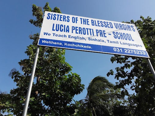
Sisters Of The Blessed Virgin's Lucia Perotti Pre- School
Negombo
School
read more
1.344 km
St. Anne's International Montessori
342/14 Welihena Road Negombo 11500 Welihena Road, Negombo
School
read more
1.375 km
St.Anne's International Montessori
171/A, Welihena Kochchikade, Negombo
School
read more
1.405 km
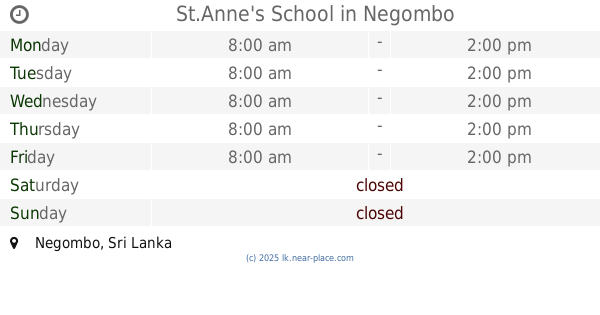
St.Anne's School
Negombo
School
read more
1.413 km
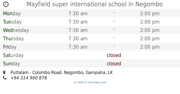
Mayfield super international school
Puttalam - Colombo Road, Negombo
School
read more
1.522 km
OKI International School, Negombo
Negombo
School
read more
1.618 km
Sudarshi Education Centre
Negombo
School
read more
1.711 km
Dalupotha Maha Vidyalaya
Negombo
School
read more
1.849 km
Vishwa High Educational Institute
Negombo
School
read more
1.889 km
Ethukala School
Negombo
School
read more
1.889 km
St. Sylvester Sinhala Mix Junior Vidyalaya
Kattuwa Road, Negombo
School
read more
1.951 km
Ng/Dutugamunu MV
School Lane, Negombo
School
read more
1.98 km
dutugemunu viddiyalaya
Negombo
School
read more
2.003 km
Palangathura Kanishta Vidyalaya
Saint Anns Road, Negombo
School
read more
2.238 km
United World College
1st Avenue, Negombo
School
read more
2.371 km
Child Garden
Cemetery Road, Negombo
School
read more
2.389 km
St. Nicholas International College - Primary and Secondary Campus
Negombo
School
read more
2.501 km
Al-Ikhlas
Abdeen Mawatta, Negombo
School
read more
2.51 km
Al-Iqrah
Thakkiya Road, Negombo
School
read more
📑
all categories
Accounting
Administrative area level 1
Administrative area level 2
Airport
Amusement park
Aquarium
Art gallery
Atm
Bakery
Bank
Bar
Beauty salon
Bicycle store
Book store
Bowling alley
Bus station
Cafe
Campground
Car dealer
Car rental
Car repair
Car wash
Casino
Cemetery
Church
City hall
Clothing store
Colloquial area
Convenience store
Country
Courthouse
Dentist
Department store
Doctor
Electrician
Electronics store
Embassy
Finance
Fire station
Florist
Food
Funeral home
Furniture store
Gas station
General contractor
Grocery or supermarket
Gym
Hair care
Hardware store
Health
Hindu Temple
Home goods store
Hospital
Insurance agency
Intersection
Jewelry store
Laundry
Lawyer
Library
Light rail station
Liquor store
Local government office
Locality
Locksmith
Lodging
Meal delivery
Meal takeaway
Mosque
Movie rental
Movie theater
Moving company
Museum
Natural feature
Neighborhood
Night club
Painter
Park
Parking
Pet store
Pharmacy
Physiotherapist
Place of worship
Plumber
Point of interest
Police
Political
Post office
Premise
Real estate agency
Restaurant
Roofing contractor
Route
Rv park, camping
School
Shoe store
Shopping mall
Spa
Stadium
Storage
Store
Subpremise
Supermarket
Synagogue
Taxi stand
Train station
Transit station
Travel agency
University
Veterinary care
Zoo
administrative area level 3
sublocality level 1
sublocality level 2
↑