School nearby Wallaweediya Primary School
Sri Lanka
School nearby Wallaweediya Primary School
Wallaweediya Primary School
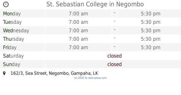
162/3, Sea Street, Negombo, Gampaha, LK Sri Lanka
contacts phone
:
+94
Latitude:
7.2179597
, Longitude:
79.8389893
larger map & directions
read more
nearest School
130 m
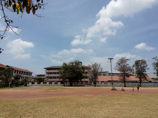
St. Sebastian College
162/3 Sea Street, Negombo
School
read more
174 m
St Sebastian School
Negombo
School
read more
188 m
ACQUIRE INSTITUTE
Negombo
School
read more
205 m
Fisheries School
Negombo
School
read more
397 m
Wijeratnam Hindu Central College
Wellaweediya
School
read more
406 m
Wijayaratnam Hindu Central College
Negombo
School
read more
549 m
Digitec Computer Systems
Ave Maria car park, Avenue Maria Road, Negombo
School
read more
595 m
School of Speech & Drama - Negombo
Ninion Mawatha, Negombo
School
read more
625 m
Azra Dathas
162/3 Sea Street, Negombo
School
read more
657 m
St. Peter's College
Fernando Avenue, Negombo
School
read more
713 m
ISO Lanka Academy
28 Colombo Road, Negombo
School
read more
758 m
Ranushka Fernando
47 Colombo Road Negombo, Negombo
School
read more
880 m
St. Mary's College
Main Street, Negombo
School
read more
883 m
Saint Joseph's College
Galison Mawatha, Negombo
School
read more
896 m
St Joseph's College
Negombo
School
read more
904 m
St.George International Teacher training Institute
387/15 Main Street, Negombo
School
read more
917 m
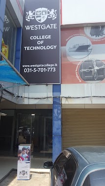
Westgate College of Technology
393, 10 Negombo - Aluthepola Road, Negombo
School
read more
933 m
Newsted Girls' College
Negombo
School
read more
943 m
Bethany Nursery School
Saunders Road, Negombo
School
read more
969 m
SPC Grosenhain
Peters Lane, Negombo
School
read more
983 m
Middlesex college
7/1 Jumma Masjid Road, Negombo
School
read more
1.028 km
Woodwork School
Negombo
School
read more
1.075 km
G-Tec Campus
22, Adnives Road, Negombo
School
read more
1.082 km
St Franciscan Convent
Negombo
School
read more
1.092 km
Child Garden
Cemetery Road, Negombo
School
read more
📑
all categories
Accounting
Administrative area level 1
Administrative area level 2
Airport
Amusement park
Aquarium
Art gallery
Atm
Bakery
Bank
Bar
Beauty salon
Bicycle store
Book store
Bowling alley
Bus station
Cafe
Campground
Car dealer
Car rental
Car repair
Car wash
Casino
Cemetery
Church
City hall
Clothing store
Colloquial area
Convenience store
Country
Courthouse
Dentist
Department store
Doctor
Electrician
Electronics store
Embassy
Finance
Fire station
Florist
Food
Funeral home
Furniture store
Gas station
General contractor
Grocery or supermarket
Gym
Hair care
Hardware store
Health
Hindu Temple
Home goods store
Hospital
Insurance agency
Intersection
Jewelry store
Laundry
Lawyer
Library
Light rail station
Liquor store
Local government office
Locality
Locksmith
Lodging
Meal delivery
Meal takeaway
Mosque
Movie rental
Movie theater
Moving company
Museum
Natural feature
Neighborhood
Night club
Painter
Park
Parking
Pet store
Pharmacy
Physiotherapist
Place of worship
Plumber
Point of interest
Police
Political
Post office
Premise
Real estate agency
Restaurant
Roofing contractor
Route
Rv park, camping
School
Shoe store
Shopping mall
Spa
Stadium
Storage
Store
Subpremise
Supermarket
Synagogue
Taxi stand
Train station
Transit station
Travel agency
University
Veterinary care
Zoo
administrative area level 3
sublocality level 1
sublocality level 2
↑