Shopping mall nearby The Lovers
Sri Lanka
Shopping mall nearby The Lovers
The Lovers
Deltota, Sri Lanka
contacts phone
:
+94 77 206 6725
Latitude:
7.1741337
, Longitude:
80.6979801
larger map & directions
read more
nearest Shopping mall
103 m
Centerpoint
Deltota
Shopping mall
read more
290 m
Multilac Paint Centre
Peradeniya-Deltota-Rikiligaskada Road, Deltota
Shopping mall
read more
293 m
RMAR Building
Deltota
Shopping mall
read more
346 m
Vijayaluxmi Stores
Deltota
Shopping mall
read more
2.835 km
Smash Rockers ORG.
Peradeniya-Deltota-Rikiligaskada Road, Galaha
Shopping mall
read more
2.835 km
Smash Rockers ORG.
B364, Galaha
Shopping mall
read more
3.955 km
Royal TElecom
Galaha
Shopping mall
read more
4.072 km
BMK STORES
B364, Galaha
Shopping mall
read more
4.072 km
BMK STORES
Peradeniya-Deltota-Rikiligaskada Road, Galaha
Shopping mall
read more
4.112 km
Balakrishna Pharmacy
Galaha
Shopping mall
read more
4.127 km
Polo Fashion
Galaha
Shopping mall
read more
4.856 km
රන්ග ස්ටෝර්ස්
Masgolla
Shopping mall
read more
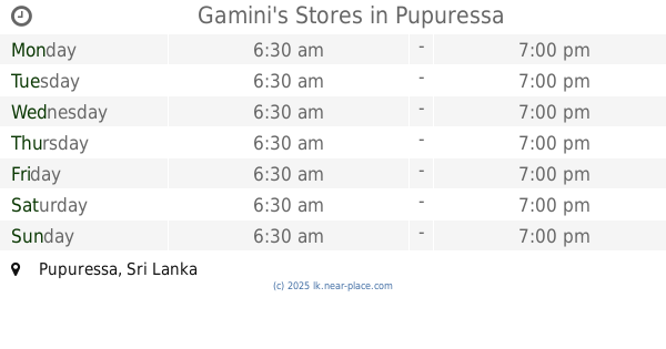
4.895 km
Gamini's Stores
Pupuressa
Shopping mall
read more
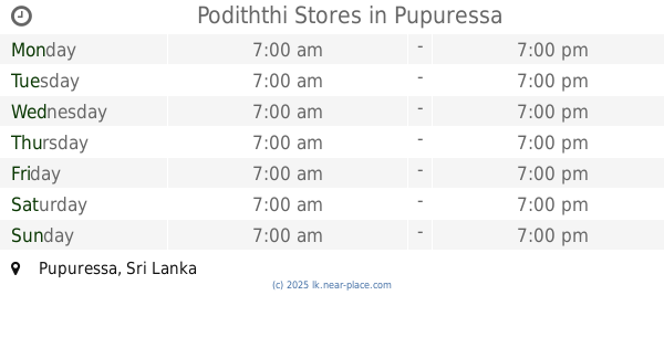
4.932 km
Podiththi Stores
Pupuressa
Shopping mall
read more
5.045 km
Sasee Stores
Galaha
Shopping mall
read more
5.053 km
Singhe Stores
Distrito de Nuwara Eliya
Shopping mall
read more
5.053 km
Singhe Stores
Nuwara Eliya
Shopping mall
read more
10.122 km
M.A.T & Sons
Peradeniya - Badulla - Chenkaladi Highway, Pussellawa
Shopping mall
read more
11.852 km
Galle City
RDA Road, Nattarampota
Shopping mall
read more
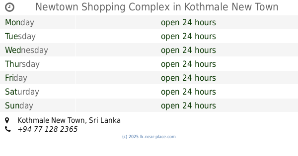
12.212 km
Newtown Shopping Complex
Kothmale New Town
Shopping mall
read more
12.484 km
Kalapura Craft Hub
Kalapura Road
Shopping mall
read more
14.688 km
ABC Engineering Pvt Ltd
Kandy
Shopping mall
read more
14.797 km
Huawei Experience Store - KCC
Kandy
Shopping mall
read more
15.215 km
Nabeesa Complex
Kandy
Shopping mall
read more
15.906 km
Grace Collectiions
Sri Dhammasiddi Mawatha, Kandy
Shopping mall
read more
📑
all categories
Accounting
Administrative area level 1
Administrative area level 2
Airport
Amusement park
Aquarium
Art gallery
Atm
Bakery
Bank
Bar
Beauty salon
Bicycle store
Book store
Bowling alley
Bus station
Cafe
Campground
Car dealer
Car rental
Car repair
Car wash
Casino
Cemetery
Church
City hall
Clothing store
Colloquial area
Convenience store
Country
Courthouse
Dentist
Department store
Doctor
Electrician
Electronics store
Embassy
Finance
Fire station
Florist
Food
Funeral home
Furniture store
Gas station
General contractor
Grocery or supermarket
Gym
Hair care
Hardware store
Health
Hindu Temple
Home goods store
Hospital
Insurance agency
Intersection
Jewelry store
Laundry
Lawyer
Library
Light rail station
Liquor store
Local government office
Locality
Locksmith
Lodging
Meal delivery
Meal takeaway
Mosque
Movie rental
Movie theater
Moving company
Museum
Natural feature
Neighborhood
Night club
Painter
Park
Parking
Pet store
Pharmacy
Physiotherapist
Place of worship
Plumber
Point of interest
Police
Political
Post office
Premise
Real estate agency
Restaurant
Roofing contractor
Route
Rv park, camping
School
Shoe store
Shopping mall
Spa
Stadium
Storage
Store
Subpremise
Supermarket
Synagogue
Taxi stand
Train station
Transit station
Travel agency
University
Veterinary care
Zoo
administrative area level 3
sublocality level 1
sublocality level 2
↑