Shopping mall nearby W.A.P Sons
Sri Lanka
Shopping mall nearby W.A.P Sons
W.A.P Sons
Gampaha, Sri Lanka
contacts phone
:
+94 112 409 703
Latitude:
6.9496984
, Longitude:
80.0574877
larger map & directions
read more
nearest Shopping mall
241 m
Ananda Jewellers
Delgoda - Pugoda Road
Shopping mall
read more
699 m
Chamathka Kandyan jewellers
Delgoda - Pugoda Road
Shopping mall
read more
758 m
Jayasity Supper
Gampaha
Shopping mall
read more
1.157 km
Nanasara Bookshop
Gampaha
Shopping mall
read more
1.245 km
Lakmal Stores
Gampaha
Shopping mall
read more
1.25 km
Lakmal Grocery
Gampaha
Shopping mall
read more
1.881 km
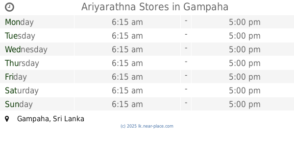
Ariyarathna Stores
Gampaha
Shopping mall
read more
2.409 km
Lakmal Stores
Dompe
Shopping mall
read more
2.561 km
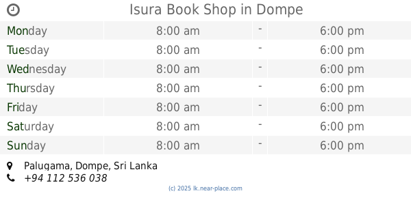
Isura Book Shop
Palugama, Dompe
Shopping mall
read more
3.878 km
Gaman Stores
Pidaliyawaththa Road
Shopping mall
read more
4.391 km
Ranil Tex
Gampaha
Shopping mall
read more
4.499 km
MSC Stores
Ulahitiwala
Shopping mall
read more
4.65 km
Rimas stores
Ulahitiwala
Shopping mall
read more
4.665 km
Hadhik Lace Center
Malwana Town
Shopping mall
read more
4.666 km
Ramzy Cut Piece
Malwana Town
Shopping mall
read more
4.696 km
Seema Stores
Ulahitiwala
Shopping mall
read more
5.122 km
Thilak Pooja Bhanda
Colombo - Hanwella Low Level Road
Shopping mall
read more
5.135 km
Samigu Medical Pharmacy
Nawagamuwa
Shopping mall
read more
5.238 km
Hanwella Shopping center
Hanwella
Shopping mall
read more
5.25 km
Fashion Side
Town, Hanwella
Shopping mall
read more
5.366 km
Hanwella New Sathi Pola
Pahala, Hanwella
Shopping mall
read more
5.392 km
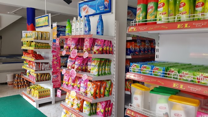
El Super City
675 Avissawella Road, Nawagamuwa
Shopping mall
read more
5.556 km
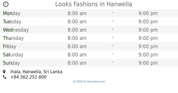
Looks Fashions
ihala, Hanwella
Shopping mall
read more
5.721 km
Kaluaggala Shopping Center
Kaluaggala-Akarawita
Shopping mall
read more
5.768 km
Gayan's Building
Sri Lanka
Shopping mall
read more
📑
all categories
Accounting
Administrative area level 1
Administrative area level 2
Airport
Amusement park
Aquarium
Art gallery
Atm
Bakery
Bank
Bar
Beauty salon
Bicycle store
Book store
Bowling alley
Bus station
Cafe
Campground
Car dealer
Car rental
Car repair
Car wash
Casino
Cemetery
Church
City hall
Clothing store
Colloquial area
Convenience store
Country
Courthouse
Dentist
Department store
Doctor
Electrician
Electronics store
Embassy
Finance
Fire station
Florist
Food
Funeral home
Furniture store
Gas station
General contractor
Grocery or supermarket
Gym
Hair care
Hardware store
Health
Hindu Temple
Home goods store
Hospital
Insurance agency
Intersection
Jewelry store
Laundry
Lawyer
Library
Light rail station
Liquor store
Local government office
Locality
Locksmith
Lodging
Meal delivery
Meal takeaway
Mosque
Movie rental
Movie theater
Moving company
Museum
Natural feature
Neighborhood
Night club
Painter
Park
Parking
Pet store
Pharmacy
Physiotherapist
Place of worship
Plumber
Point of interest
Police
Political
Post office
Premise
Real estate agency
Restaurant
Roofing contractor
Route
Rv park, camping
School
Shoe store
Shopping mall
Spa
Stadium
Storage
Store
Subpremise
Supermarket
Synagogue
Taxi stand
Train station
Transit station
Travel agency
University
Veterinary care
Zoo
administrative area level 3
sublocality level 1
sublocality level 2
↑