Store nearby Christi Stores
Sri Lanka
Store nearby Christi Stores
Christi Stores
Pupuressa, Sri Lanka
contacts phone
:
+94
Latitude:
7.1296671
, Longitude:
80.663731
larger map & directions
read more
nearest Store
29 m
Litro Gas Station
Galaha - Pupuressa Road, Pupuressa
Store
read more
52 m
Dhanapala Stores
Pupuressa
Store
read more
3.294 km
Kusal Stores
Gampola - Pupuressa Rd, Udapalatha
Store
read more
3.634 km
Saru International Pussallawa Branch
Peradeniya - Badulla - Chenkaladi Highway, Pussellawa
Store
read more
3.913 km
Arthy Jewellers
Peradeniya - Badulla - Chenkaladi Highway, Pussellawa
Store
read more
3.916 km
Rashi and Nab Tech Zone
Pussellawa
Store
read more
4.002 km
Pushpa Stores
Pussellawa
Store
read more
4.005 km
New Lucky Stores
Pussellawa
Store
read more
4.016 km
Rathnayake Stores
Pussellawa
Store
read more
4.045 km
Ruby Trade Centre
500 Nuwaraeliya Road, Pussellawa
Store
read more
4.091 km
N.M PRODUCTS
DM Jayarathna Mawatha, Udapalatha
Store
read more
4.123 km
Kothmale Wasana Tea Kade/ Tea Shop
Kandy
Store
read more
4.359 km
Orangefield Tea Factory
Galaha - Pupuressa - Delpitiya (Section 2) Road
Store
read more
4.375 km
Ganhewa Stores
Store
read more
4.797 km
Erin Tea Factory
Galaha - Pupuressa - Delpitiya Road
Store
read more
5.707 km
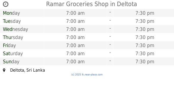
Ramar Groceries Shop
Deltota
Store
read more
5.738 km
recharge srilanka
No.24,Hewaheta Road,, Deltota, Kandy
Store
read more
5.913 km
Ismiyas Stationery
Peradeniya-Deltota-Rikiligaskada Road, Deltota
Store
read more
6.135 km
mkm fruits and grocery
Market, Peradeniya-Deltota-Rikiligaskada Road, Deltota
Store
read more
6.159 km
Delon Pharmcy
Deltota
Store
read more
6.175 km
New Line Fancy
Market, Wadiyagoda Road, Deltota
Store
read more
6.347 km
Delon Pharmcy
C-1,central market, Deltota
Store
read more
13.479 km
D.K.Cellular
Sri Lanka
Store
read more
16.798 km
Luxmi Stores
42,penithudumulla Road Nawalapitiya
Store
read more
17.833 km
Sanka Stores
Wattappola
Store
read more
📑
all categories
Accounting
Administrative area level 1
Administrative area level 2
Airport
Amusement park
Aquarium
Art gallery
Atm
Bakery
Bank
Bar
Beauty salon
Bicycle store
Book store
Bowling alley
Bus station
Cafe
Campground
Car dealer
Car rental
Car repair
Car wash
Casino
Cemetery
Church
City hall
Clothing store
Colloquial area
Convenience store
Country
Courthouse
Dentist
Department store
Doctor
Electrician
Electronics store
Embassy
Finance
Fire station
Florist
Food
Funeral home
Furniture store
Gas station
General contractor
Grocery or supermarket
Gym
Hair care
Hardware store
Health
Hindu Temple
Home goods store
Hospital
Insurance agency
Intersection
Jewelry store
Laundry
Lawyer
Library
Light rail station
Liquor store
Local government office
Locality
Locksmith
Lodging
Meal delivery
Meal takeaway
Mosque
Movie rental
Movie theater
Moving company
Museum
Natural feature
Neighborhood
Night club
Painter
Park
Parking
Pet store
Pharmacy
Physiotherapist
Place of worship
Plumber
Point of interest
Police
Political
Post office
Premise
Real estate agency
Restaurant
Roofing contractor
Route
Rv park, camping
School
Shoe store
Shopping mall
Spa
Stadium
Storage
Store
Subpremise
Supermarket
Synagogue
Taxi stand
Train station
Transit station
Travel agency
University
Veterinary care
Zoo
administrative area level 3
sublocality level 1
sublocality level 2
↑