Store nearby Dinesh Phone center And Gift.
Sri Lanka
Store nearby Dinesh Phone center And Gift.
Dinesh Phone center And Gift.
Marawila, Sri Lanka
contacts phone
:
+94
Latitude:
7.4119678
, Longitude:
79.8311237
larger map & directions
read more
nearest Store
110 m
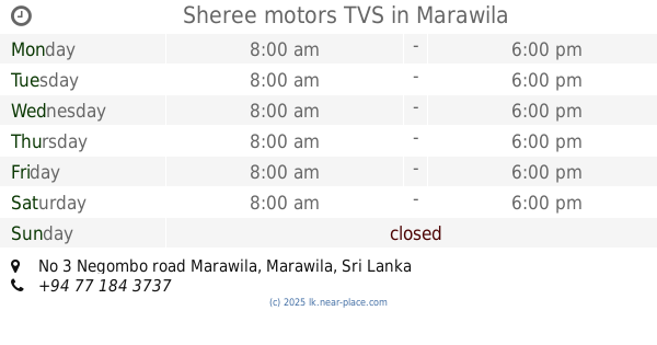
Sheree motors TVS
No 3 Negombo road Marawila
Store
read more
114 m
Colambo Shoe Mart
948 Marawila - Nattandiya Rd, Marawila 61210 Marawila - Nattandiya Road, Marawila
Store
read more
122 m
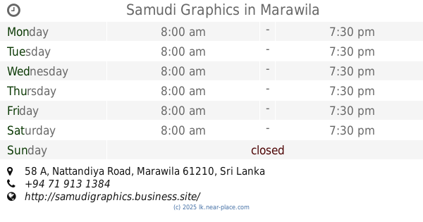
Samudi Graphics
58 A, Nattandiya Road, Marawila
Store
read more
132 m
Merh Roo Phone Centre
948 Marawila - Nattandiya Rd Marawila 61210 Marawila - Nattandiya Road, Marawila
Store
read more
163 m
Shorn Enterprises
Marawila
Store
read more
785 m
Akein Enterprises
61210, Marawila
Store
read more
792 m
Flower Cabin
Chilaw - Colombo Main Road, Marawila
Store
read more
795 m
GSM phone shop
Chilaw - Colombo Main Road, Marawila
Store
read more
805 m
Asanka Graphics & Printers
Mudukatuwa, Marawila
Store
read more
877 m
Mudukatuwa Oil Mart
Chilaw - Colombo Main Road, Marawila
Store
read more
1.055 km
Suvinlak Medical Center and Laboratory
Chilaw - Colombo Main Road, Marawila
Store
read more
1.137 km
Chooti Duwa Farm Shop
Chilaw - Colombo Main Road, Marawila
Store
read more
1.218 km
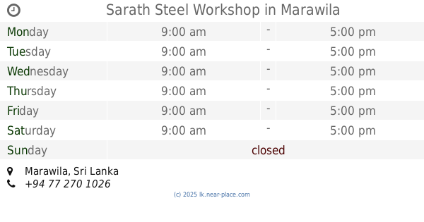
Sarath Steel Workshop
Marawila
Store
read more
1.236 km
Sameera Phone Shop
Chilaw - Colombo Main Road, Marawila
Store
read more
1.878 km
Madhushika Timber Stores
Marawila
Store
read more
2.344 km
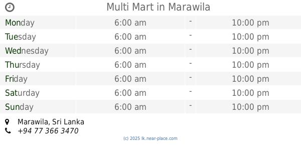
Multi Mart
Marawila
Store
read more
2.418 km
Pramith Ref And Air
Nattandiya
Store
read more
2.7 km
SHYAMALIE SUPPLIERS
Mudukatuwa, Marawila
Store
read more
2.844 km
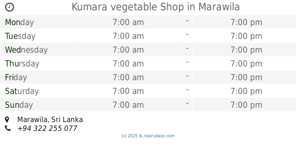
Kumara vegetable Shop
Marawila
Store
read more
2.878 km
Tissera Stores
Marawila
Store
read more
2.927 km
Shenal Trade Center
Puttalam - Colombo Road, Mudukatuwa
Store
read more
3.032 km
L.P.B. Beach Park
Beach Road, Marawila
Store
read more
3.271 km
Green Farms (Pvt) Ltd.
Pahala Walahapitiya Road, Marawila
Store
read more
4.321 km
Anton Stors
Mahawewa
Store
read more
5.961 km
glossy printers.
Ihala Kottaramulla
Store
read more
📑
all categories
Accounting
Administrative area level 1
Administrative area level 2
Airport
Amusement park
Aquarium
Art gallery
Atm
Bakery
Bank
Bar
Beauty salon
Bicycle store
Book store
Bowling alley
Bus station
Cafe
Campground
Car dealer
Car rental
Car repair
Car wash
Casino
Cemetery
Church
City hall
Clothing store
Colloquial area
Convenience store
Country
Courthouse
Dentist
Department store
Doctor
Electrician
Electronics store
Embassy
Finance
Fire station
Florist
Food
Funeral home
Furniture store
Gas station
General contractor
Grocery or supermarket
Gym
Hair care
Hardware store
Health
Hindu Temple
Home goods store
Hospital
Insurance agency
Intersection
Jewelry store
Laundry
Lawyer
Library
Light rail station
Liquor store
Local government office
Locality
Locksmith
Lodging
Meal delivery
Meal takeaway
Mosque
Movie rental
Movie theater
Moving company
Museum
Natural feature
Neighborhood
Night club
Painter
Park
Parking
Pet store
Pharmacy
Physiotherapist
Place of worship
Plumber
Point of interest
Police
Political
Post office
Premise
Real estate agency
Restaurant
Roofing contractor
Route
Rv park, camping
School
Shoe store
Shopping mall
Spa
Stadium
Storage
Store
Subpremise
Supermarket
Synagogue
Taxi stand
Train station
Transit station
Travel agency
University
Veterinary care
Zoo
administrative area level 3
sublocality level 1
sublocality level 2
↑