Store nearby Doragala tea Factory
Sri Lanka
Store nearby Doragala tea Factory
Doragala tea Factory
Ulapane - Pussellawa Rd, Kandy, Central Province, LK Sri Lanka
contacts phone
:
+94 71 537 2330
Latitude:
7.081079
, Longitude:
80.6104338
larger map & directions
read more
nearest Store
1.457 km
Rohan Multi Care
Kandy
Store
read more
1.734 km
Pushpa Stores
391, Nuwara Eliya -Uda Pussellawa Road, Ragala
Store
read more
3.366 km
P.K.R Fancy & Comunication
No.92 Road Paradeka, Nuwara Eliya
Store
read more
4.006 km
N.M PRODUCTS
DM Jayarathna Mawatha, Udapalatha
Store
read more
4.019 km
Ruby Trade Centre
500 Nuwaraeliya Road, Pussellawa
Store
read more
4.052 km
New Lucky Stores
Pussellawa
Store
read more
4.053 km
Pushpa Stores
Pussellawa
Store
read more
4.108 km
Arthy Jewellers
Peradeniya - Badulla - Chenkaladi Highway, Pussellawa
Store
read more
4.113 km
Rashi and Nab Tech Zone
Pussellawa
Store
read more
4.225 km
Rathnayake Stores
Pussellawa
Store
read more
4.327 km
Kothmale Wasana Tea Kade/ Tea Shop
Kandy
Store
read more
4.605 km
Saru International Pussallawa Branch
Peradeniya - Badulla - Chenkaladi Highway, Pussellawa
Store
read more
5.628 km
Ihshan's
Kandy
Store
read more
6.091 km
Solid Lanka Roofing (Pvt) Ltd
Ulapane Industrial Estate, Ulapane
Store
read more
6.292 km
CO-OP Service
SAARC Village
Store
read more
6.394 km
Farm's Pride (Pvt) Ltd
Kandy Road, Ethgala
Store
read more
9.159 km
Luxmi Stores
42,penithudumulla Road Nawalapitiya
Store
read more
9.653 km
Milco Sales Outlet
Kandy Road
Store
read more
10.136 km
E life Printing Centre
Nawalapitiya Road, Gampola
Store
read more
10.216 km
United Glass House
42 a, නුවර පාර, Gampola
Store
read more
13.688 km
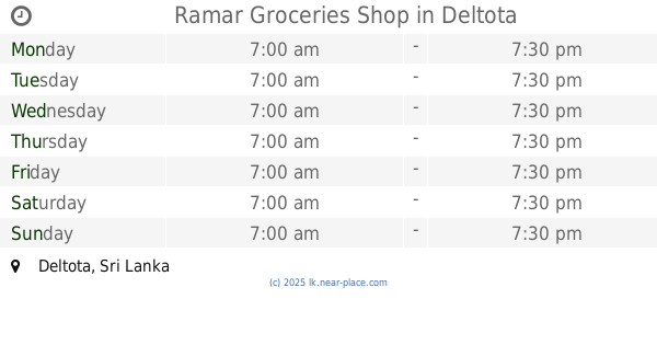
Ramar Groceries Shop
Deltota
Store
read more
14.078 km
Delon Pharmcy
Deltota
Store
read more
14.524 km
K.M.L International Hardware
Galaha
Store
read more
16.104 km
Santha Motors
b/7, Hakurugammana-Pinwaththa-Hemmathagama Road, Aranayaka
Store
read more
16.843 km
Carolina Tea Factory
122, Avissawella-Hatton-Nuwara Eliya Highway
Store
read more
📑
all categories
Accounting
Administrative area level 1
Administrative area level 2
Airport
Amusement park
Aquarium
Art gallery
Atm
Bakery
Bank
Bar
Beauty salon
Bicycle store
Book store
Bowling alley
Bus station
Cafe
Campground
Car dealer
Car rental
Car repair
Car wash
Casino
Cemetery
Church
City hall
Clothing store
Colloquial area
Convenience store
Country
Courthouse
Dentist
Department store
Doctor
Electrician
Electronics store
Embassy
Finance
Fire station
Florist
Food
Funeral home
Furniture store
Gas station
General contractor
Grocery or supermarket
Gym
Hair care
Hardware store
Health
Hindu Temple
Home goods store
Hospital
Insurance agency
Intersection
Jewelry store
Laundry
Lawyer
Library
Light rail station
Liquor store
Local government office
Locality
Locksmith
Lodging
Meal delivery
Meal takeaway
Mosque
Movie rental
Movie theater
Moving company
Museum
Natural feature
Neighborhood
Night club
Painter
Park
Parking
Pet store
Pharmacy
Physiotherapist
Place of worship
Plumber
Point of interest
Police
Political
Post office
Premise
Real estate agency
Restaurant
Roofing contractor
Route
Rv park, camping
School
Shoe store
Shopping mall
Spa
Stadium
Storage
Store
Subpremise
Supermarket
Synagogue
Taxi stand
Train station
Transit station
Travel agency
University
Veterinary care
Zoo
administrative area level 3
sublocality level 1
sublocality level 2
↑