Store nearby Mallika Stores
Sri Lanka
Store nearby Mallika Stores
Mallika Stores
No/104,Tissa Rd,Netolpitiya, Sri Lanka
contacts phone
:
+94 472 242 874
Latitude:
6.0699774
, Longitude:
80.8441183
larger map & directions
read more
nearest Store
1.024 km
Wijenayaka Oil Mart
Netolpitiya
Store
read more
3.095 km
rekawa surfing point
Oruwella Road, rekawa, netolpitiya, Hambantota
Store
read more
4.321 km
M.W.P. Oil Centre
Ranna
Store
read more
4.335 km
Mac Raw Enterprises
20 A2, Ranna
Store
read more
4.533 km
CB Computers
A2, Ranna
Store
read more
4.616 km
Dew E - Center
Ranna
Store
read more
4.79 km
Pradeep Vision
Ranna - Udayala - Weeraketiya Road, Ranna
Store
read more
5.483 km
New Standard Motors
Anandarama Temple Juntion, 100 Feet Road , ranna., Ranna - (Agunukola) - Embilipitiya Road
Store
read more
6.095 km
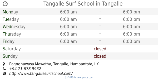
Tangalle Surf School
Pagngnawasa Mawatha, Tangalle
Store
read more
6.739 km
A&G Technologies
Thissa Road, Tangalle
Store
read more
6.879 km
Southern Motors (Bajaj Motorbike dealer)
Colombo - Galle - Hambantota - Wellawaya Highway, Tangalle
Store
read more
7.026 km
Eser Marketing Fitness (Pvt) Ltd
No 42, Hambanthota Rd,, Tangalle
Store
read more
7.168 km
Samsurfing school
Sea Avenues, Tangalle
Store
read more
7.239 km
Isuru Phone House
Medaketiya Road, Tangalle
Store
read more
7.242 km
Dress Line
A2, Tangalle
Store
read more
7.476 km
E-Tel Mobile
Matara Road, Tangalle
Store
read more
9.491 km
DVS Stores
Beliatta - Tangalle Road, Sitinamaluwa South
Store
read more
12.329 km
HPM phone shop
Beliatta
Store
read more
12.349 km
Chandana Pharmacy
Beliatta
Store
read more
12.397 km
Duminda tvs
Weeraketiya - Middeniya Road, Weeraketiya
Store
read more
12.462 km
Nelika Shoe Center
Beliatta
Store
read more
12.793 km
Sagara Stores
B622, Mulana
Store
read more
13.056 km
Janith Stores
Kiula, A2, Hungama
Store
read more
16.566 km
Sasanka Walikoratuwa
Walasmulla
Store
read more
19.236 km
Kome Kade Stores
Hambantota
Store
read more
📑
all categories
Accounting
Administrative area level 1
Administrative area level 2
Airport
Amusement park
Aquarium
Art gallery
Atm
Bakery
Bank
Bar
Beauty salon
Bicycle store
Book store
Bowling alley
Bus station
Cafe
Campground
Car dealer
Car rental
Car repair
Car wash
Casino
Cemetery
Church
City hall
Clothing store
Colloquial area
Convenience store
Country
Courthouse
Dentist
Department store
Doctor
Electrician
Electronics store
Embassy
Finance
Fire station
Florist
Food
Funeral home
Furniture store
Gas station
General contractor
Grocery or supermarket
Gym
Hair care
Hardware store
Health
Hindu Temple
Home goods store
Hospital
Insurance agency
Intersection
Jewelry store
Laundry
Lawyer
Library
Light rail station
Liquor store
Local government office
Locality
Locksmith
Lodging
Meal delivery
Meal takeaway
Mosque
Movie rental
Movie theater
Moving company
Museum
Natural feature
Neighborhood
Night club
Painter
Park
Parking
Pet store
Pharmacy
Physiotherapist
Place of worship
Plumber
Point of interest
Police
Political
Post office
Premise
Real estate agency
Restaurant
Roofing contractor
Route
Rv park, camping
School
Shoe store
Shopping mall
Spa
Stadium
Storage
Store
Subpremise
Supermarket
Synagogue
Taxi stand
Train station
Transit station
Travel agency
University
Veterinary care
Zoo
administrative area level 3
sublocality level 1
sublocality level 2
↑