Store nearby Mihiri Motors
Sri Lanka
Store nearby Mihiri Motors
Mihiri Motors
Homagama, Sri Lanka
contacts phone
:
+94 77 745 5572
Latitude:
6.8405461
, Longitude:
79.9966847
larger map & directions
read more
nearest Store
302 m
Pharmacy
Galavilawatta North, Homagama
Store
read more
304 m
The Che
541/E Sashanawardanarama Mawatha, Homagama
Store
read more
458 m
Richy Tea Manufacturers
Galagedara Sugathananda Nahime Mawatha, Homagama
Store
read more
471 m
Sanvek Traders
Sashanawardanarama Mawatha, Homagama
Store
read more
591 m
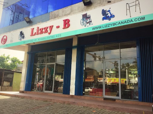
Lizzyb (Pvt) Ltd
187 Avissawella Road, Homagama
Store
read more
640 m
Gunasiri Ayurvedic shop
Galavilawatta North, Homagama
Store
read more
678 m
Janani Jewellers
No :22 rd,, හෝමාගම
Store
read more
683 m
MD Computer Solutions, Homagama
36c/1, 144/1 Homagama-Diyagama Road, Homagama
Store
read more
706 m
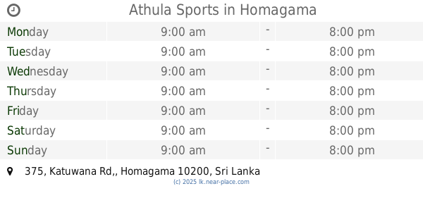
Athula Sports
375, Katuwana Rd,, Homagama
Store
read more
734 m
Lanka Tea Room
Colombo - Batticaloa Highway, Homagama
Store
read more
749 m
New Nugegoda Electricals
No:45, Station Road, Homagama,
Store
read more
753 m
New Homagama Less Center
No:45/1, Station Road, Homagama,
Store
read more
797 m
Laser Mobile Phone Arcade
No. 56, High Level Road, Homagama
Store
read more
818 m
Ayurwedha Medical Store
Station Road, Homagama
Store
read more
831 m
baby talk
75/6 senanayaka shopping complex statoin road homagama
Store
read more
833 m
Isuru Curtain Center
No:18, Senanayake shopping complex, Station Road, Homagama,
Store
read more
848 m
K.A. Mobile
Sri Lanka
Store
read more
879 m
TMJ COMPUTERS
Homagama-Diyagama Road, Homagama
Store
read more
884 m
MK Technologies
Homagama
Store
read more
894 m
Suwahasa Pharmacy
8 Avissawella Road, Homagama
Store
read more
933 m
Nadun Sanaa Tatoo Art Studio
Homagama Town, Homagama
Store
read more
978 m
Sithuka Stores
8 Avissawella Road, Homagama
Store
read more
1000 m
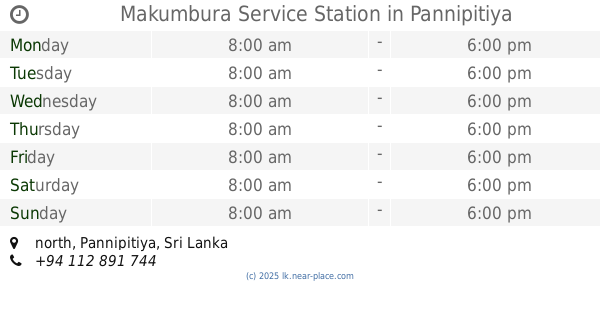
Makumbura Service Station
north, Pannipitiya
Store
read more
1.009 km
Channa Communication
Homagama
Store
read more
1.06 km
Senavirathna Printers
Mawathgama, Homagama
Store
read more
📑
all categories
Accounting
Administrative area level 1
Administrative area level 2
Airport
Amusement park
Aquarium
Art gallery
Atm
Bakery
Bank
Bar
Beauty salon
Bicycle store
Book store
Bowling alley
Bus station
Cafe
Campground
Car dealer
Car rental
Car repair
Car wash
Casino
Cemetery
Church
City hall
Clothing store
Colloquial area
Convenience store
Country
Courthouse
Dentist
Department store
Doctor
Electrician
Electronics store
Embassy
Finance
Fire station
Florist
Food
Funeral home
Furniture store
Gas station
General contractor
Grocery or supermarket
Gym
Hair care
Hardware store
Health
Hindu Temple
Home goods store
Hospital
Insurance agency
Intersection
Jewelry store
Laundry
Lawyer
Library
Light rail station
Liquor store
Local government office
Locality
Locksmith
Lodging
Meal delivery
Meal takeaway
Mosque
Movie rental
Movie theater
Moving company
Museum
Natural feature
Neighborhood
Night club
Painter
Park
Parking
Pet store
Pharmacy
Physiotherapist
Place of worship
Plumber
Point of interest
Police
Political
Post office
Premise
Real estate agency
Restaurant
Roofing contractor
Route
Rv park, camping
School
Shoe store
Shopping mall
Spa
Stadium
Storage
Store
Subpremise
Supermarket
Synagogue
Taxi stand
Train station
Transit station
Travel agency
University
Veterinary care
Zoo
administrative area level 3
sublocality level 1
sublocality level 2
↑