Store nearby Nimal Opticals 34/A
Sri Lanka
Store nearby Nimal Opticals 34/A
Nimal Opticals 34/A
2nd Rohini Lane, Colombo, Colombo, LK Sri Lanka
contacts phone
:
+94
Latitude:
6.9359057
, Longitude:
79.8505667
larger map & directions
read more
nearest Store
42 m
Vista Phone Centre
Sri Lanka
Store
read more
51 m
Henly Electricals
100/14 1st Cross Street, Colombo
Store
read more
61 m
N.S GENERAL TRADING
1st Cross Street, Colombo
Store
read more
93 m
Gift Enterprise
1st Cross Street, Colombo
Store
read more
122 m
Royalty MSB PVT LTD
Maliban Street, Colombo
Store
read more
152 m
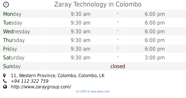
Zaray Technology
Colombo 11, 11 Western Province
Store
read more
165 m
Royal Sweet Garden
Colombo 11, Colombo
Store
read more
182 m
Khazana Sports
1st Cross Street, Colombo
Store
read more
183 m
Bodyline
118a, Keyzer Street, Colombo
Store
read more
186 m
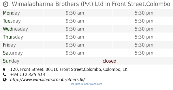
Wimaladharma Brothers (Pvt) Ltd
120 Front Street, Front Street,Colombo
Store
read more
192 m
Alliance Lanka
No 156 second cross street, 11, Colombo
Store
read more
213 m
DH-enterprises
No,100,1/29,Keyzer Street Colombo,11, Colombo
Store
read more
214 m
Blue Net Phone Shop
57, Olcott Mawatha, Colombo
Store
read more
216 m
ST. DALFOUR SRI LANKA
145 Prince Street, Colombo
Store
read more
217 m
M. R TRADERS
Colombo
Store
read more
226 m
Devika Stores
Olcott Mawatha, Colombo
Store
read more
230 m
Sequins
167A Main Street,, Colombo 11
Store
read more
233 m
Takhai Mobiles
148 Main Street, Colombo
Store
read more
247 m
S.A ENTERPRISES MARKET
Colombo
Store
read more
255 m
New zam zam
163, Prince Street, Colombo
Store
read more
356 m
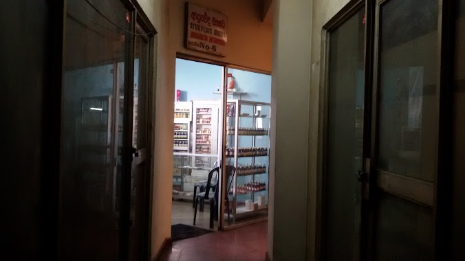
Jayashakthi (Kapaadia) Ayurvedic Centre
Colombo 11
Store
read more
682 m
Commerce Universal
New Moor Street, Colombo
Store
read more
810 m
Sir Edward Barnes Statue
Colombo
Store
read more
837 m
British Cosmetics
Bank of Ceylon Mawatha, Colombo
Store
read more
1.023 km
HILLMARK TRATEING
154 Old Moor Street, Colombo
Store
read more
📑
all categories
Accounting
Administrative area level 1
Administrative area level 2
Airport
Amusement park
Aquarium
Art gallery
Atm
Bakery
Bank
Bar
Beauty salon
Bicycle store
Book store
Bowling alley
Bus station
Cafe
Campground
Car dealer
Car rental
Car repair
Car wash
Casino
Cemetery
Church
City hall
Clothing store
Colloquial area
Convenience store
Country
Courthouse
Dentist
Department store
Doctor
Electrician
Electronics store
Embassy
Finance
Fire station
Florist
Food
Funeral home
Furniture store
Gas station
General contractor
Grocery or supermarket
Gym
Hair care
Hardware store
Health
Hindu Temple
Home goods store
Hospital
Insurance agency
Intersection
Jewelry store
Laundry
Lawyer
Library
Light rail station
Liquor store
Local government office
Locality
Locksmith
Lodging
Meal delivery
Meal takeaway
Mosque
Movie rental
Movie theater
Moving company
Museum
Natural feature
Neighborhood
Night club
Painter
Park
Parking
Pet store
Pharmacy
Physiotherapist
Place of worship
Plumber
Point of interest
Police
Political
Post office
Premise
Real estate agency
Restaurant
Roofing contractor
Route
Rv park, camping
School
Shoe store
Shopping mall
Spa
Stadium
Storage
Store
Subpremise
Supermarket
Synagogue
Taxi stand
Train station
Transit station
Travel agency
University
Veterinary care
Zoo
administrative area level 3
sublocality level 1
sublocality level 2
↑