Supermarket nearby Shiwantha stores
Sri Lanka
Supermarket nearby Shiwantha stores
Shiwantha stores
Kalutara Sri Lanka
contacts phone
:
+94
Latitude:
6.5377491
, Longitude:
80.2700029
read more
nearest Supermarket
4.742 km
Kavirathna Stores
Baduraliya
Supermarket
read more
8.043 km
Thabaawita Stros
Hedigalla Road, Hedigalla
Supermarket
read more
12 km
Kandy Stores
Ayagama
Supermarket
read more
12.025 km
Sampath Food City
Tiruwanaketiya-Agalawatte Road, Agalawatta
Supermarket
read more
13.979 km
Mahajana Stores
Manana
Supermarket
read more
13.985 km
Disanayaka Stores
Tiruwanaketiya-Agalawatte Road, Manana
Supermarket
read more
15.81 km
GALPATHA SUPER STORE
Bulathsinhala
Supermarket
read more
16.547 km
Anura Super Market
Horana - Bulathsinhala - Mathugama Road, Matugama
Supermarket
read more
17.349 km
Kannangara Trade Center
No 36, Road, Matugama
Supermarket
read more
21.558 km
Sathosa, Ratnapura
Ratnapura
Supermarket
read more
21.691 km
Anuja Bangalawa
Nivithigala
Supermarket
read more
22.057 km
Sampath Shopping Center
Galle
Supermarket
read more
22.17 km
Co-op City
B158, Pitigala
Supermarket
read more
22.687 km
Cargills Food City Express
Sri Lanka
Supermarket
read more
23.164 km
Januka Stors
Kalutara
Supermarket
read more
23.273 km
Jayasinghe Super
Aluthgama - Mathugama Road, Walagedara
Supermarket
read more
23.515 km
Jayasingha HardWare-grosary
Kalutara
Supermarket
read more
24.014 km
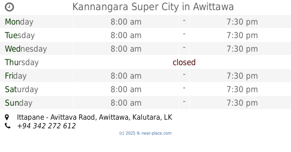
Kannangara Super City
Ittapane - Avittava Raod, Awittawa
Supermarket
read more
25.302 km
Super Market
Meepe - Ingiriya Road, Ingiriya
Supermarket
read more
25.307 km
Arpico Daily
No. 96, Bandaranayeka Road, Ingiriya
Supermarket
read more
27.265 km
Winlan Super City
Winlan Super, Walpita Road, Ballapitiya
Supermarket
read more
27.506 km
Mini Co-Op City Ilimba
Horana
Supermarket
read more
28.512 km
Budjet Shop
Horana
Supermarket
read more
28.709 km
SISIRA Food City
Ilimba, A8, Horana
Supermarket
read more
29.667 km
CO-OP City Munagama
450 Ratnapura - Horana - Panadura Highway, Horana
Supermarket
read more
📑
all categories
Accounting
Administrative area level 1
Administrative area level 2
Airport
Amusement park
Aquarium
Art gallery
Atm
Bakery
Bank
Bar
Beauty salon
Bicycle store
Book store
Bowling alley
Bus station
Cafe
Campground
Car dealer
Car rental
Car repair
Car wash
Casino
Cemetery
Church
City hall
Clothing store
Colloquial area
Convenience store
Country
Courthouse
Dentist
Department store
Doctor
Electrician
Electronics store
Embassy
Finance
Fire station
Florist
Food
Funeral home
Furniture store
Gas station
General contractor
Grocery or supermarket
Gym
Hair care
Hardware store
Health
Hindu Temple
Home goods store
Hospital
Insurance agency
Intersection
Jewelry store
Laundry
Lawyer
Library
Light rail station
Liquor store
Local government office
Locality
Locksmith
Lodging
Meal delivery
Meal takeaway
Mosque
Movie rental
Movie theater
Moving company
Museum
Natural feature
Neighborhood
Night club
Painter
Park
Parking
Pet store
Pharmacy
Physiotherapist
Place of worship
Plumber
Point of interest
Police
Political
Post office
Premise
Real estate agency
Restaurant
Roofing contractor
Route
Rv park, camping
School
Shoe store
Shopping mall
Spa
Stadium
Storage
Store
Subpremise
Supermarket
Synagogue
Taxi stand
Train station
Transit station
Travel agency
University
Veterinary care
Zoo
administrative area level 3
sublocality level 1
sublocality level 2
↑