Supermarket nearby Suhada Pharmacy & Super Market
Sri Lanka
Supermarket nearby Suhada Pharmacy & Super Market
Suhada Pharmacy & Super Market
Corea Street, Chilaw, Puttalam, LK Sri Lanka
contacts phone
:
+94 322 223 474
Latitude:
7.5763369
, Longitude:
79.7955385
larger map & directions
read more
nearest Supermarket
310 m
Arpico Daily Chilaw
Chilaw
Supermarket
read more
316 m
Cargills Food City - Chilaw 1
1 Jetty Street, Chilaw
Supermarket
read more
553 m
Laughs super market
Chilaw
Supermarket
read more
942 m
Cargills Food City - Chilaw 2
98 Chilaw - Colombo Main Road, Chilaw
Supermarket
read more
1.434 km
NMK STORES
Chilaw
Supermarket
read more
2.586 km
Inshaf Stores
Sawarana, Chilaw
Supermarket
read more
2.588 km
Family Food Center
Chilaw
Supermarket
read more
3.764 km
Costa Stores
Chilaw-Wariyapola Road, Chilaw
Supermarket
read more
3.764 km
Costa Stores
Wariyapola Road, Chilaw
Supermarket
read more
6.826 km
COOP Super
Manakkulama Government School
Supermarket
read more
7.579 km
Sachini Stores
kottapitiya
Supermarket
read more
7.611 km
samalka stors and hardweare
Iranawila
Supermarket
read more
10.094 km
Cargills Food City Express Madampe.
No. 33, Station Road, Madampe
Supermarket
read more
10.268 km
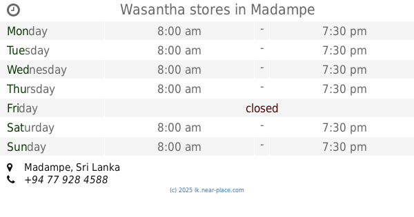
Wasantha stores
Madampe
Supermarket
read more
10.302 km
M.E SUPER
Thoduwawa
Supermarket
read more
10.327 km
Cooperative Shop
Madampe
Supermarket
read more
10.594 km
Ravindra Mini Super
Heenagara, Puttalam
Supermarket
read more
14.566 km
K.M. Super Market
Puttalam
Supermarket
read more
14.599 km
Best Life Prosumer City
Mahawewa Franchise, Chilaw - Colombo Main Road
Supermarket
read more
16.224 km
SonIro Mini Marcket
No.55 Golden City, Hiralumulla, Dummalasuriya
Supermarket
read more
19.545 km
Canrota Mart
Marawila
Supermarket
read more
20.6 km
Padiwela Market
Bowatta-Padiwela Road
Supermarket
read more
21.065 km
Meda getulawa M. C. C.
Kurunegala
Supermarket
read more
21.47 km
DUVINDU store
Udubaddawa
Supermarket
read more
22.875 km
MR Stores
Negombo road, Pahala Kottaramulla
Supermarket
read more
📑
all categories
Accounting
Administrative area level 1
Administrative area level 2
Airport
Amusement park
Aquarium
Art gallery
Atm
Bakery
Bank
Bar
Beauty salon
Bicycle store
Book store
Bowling alley
Bus station
Cafe
Campground
Car dealer
Car rental
Car repair
Car wash
Casino
Cemetery
Church
City hall
Clothing store
Colloquial area
Convenience store
Country
Courthouse
Dentist
Department store
Doctor
Electrician
Electronics store
Embassy
Finance
Fire station
Florist
Food
Funeral home
Furniture store
Gas station
General contractor
Grocery or supermarket
Gym
Hair care
Hardware store
Health
Hindu Temple
Home goods store
Hospital
Insurance agency
Intersection
Jewelry store
Laundry
Lawyer
Library
Light rail station
Liquor store
Local government office
Locality
Locksmith
Lodging
Meal delivery
Meal takeaway
Mosque
Movie rental
Movie theater
Moving company
Museum
Natural feature
Neighborhood
Night club
Painter
Park
Parking
Pet store
Pharmacy
Physiotherapist
Place of worship
Plumber
Point of interest
Police
Political
Post office
Premise
Real estate agency
Restaurant
Roofing contractor
Route
Rv park, camping
School
Shoe store
Shopping mall
Spa
Stadium
Storage
Store
Subpremise
Supermarket
Synagogue
Taxi stand
Train station
Transit station
Travel agency
University
Veterinary care
Zoo
administrative area level 3
sublocality level 1
sublocality level 2
↑