Supermarket nearby Uththarapala store
Sri Lanka
Supermarket nearby Uththarapala store
Uththarapala store
Adhikarigama Sri Lanka
contacts phone
:
+94
Latitude:
7.2142894
, Longitude:
80.7824537
read more
nearest Supermarket
4.031 km
Sampath Traders
Hanguranketa
Supermarket
read more
4.14 km
Darshana Super
Boralassa Road, Hanguranketa
Supermarket
read more
4.339 km
Ududeniya O.M.R.Stores
Marassana - Ududeniya Road, Marassana
Supermarket
read more
4.828 km
Keerthi Super
No 57,Ragala Road,Rikillagaskada
Supermarket
read more
7.604 km
supun fresh fruit
B413, Rikillagaskada
Supermarket
read more
7.677 km
Keerthi Super
No57,Ragala Road,Rikillagaskada
Supermarket
read more
10.142 km
Cargills Food City - Pallekele
No. 396, Digana Road, Pallekele
Supermarket
read more
10.813 km
Co-Op City
Kandy-Kirimetiya Road, Thalathuoya
Supermarket
read more
10.831 km
SINGHE FAMILY SUPER
NEW TOWN DIGANA RAJAWELLA, A26, Digana
Supermarket
read more
10.839 km
Udadumbara Stores
A26, Digana
Supermarket
read more
10.944 km
Singhe Super
Karalliyadda
Supermarket
read more
12.546 km
SIRIKATHA TRADERS
211/, 1st Lane, මහනුවර
Supermarket
read more
13.936 km
Lanka Sathosa
Nattarampota
Supermarket
read more
14.302 km
Star United
Digana Road, Manikkhinna, Kandy
Supermarket
read more
14.64 km
Samupakara Thoga Sansthawa
Menikhinna
Supermarket
read more
14.667 km
COOP Super
Madawala - Rajawella Road, Menikhinna
Supermarket
read more
14.752 km
Udawela Stores
Menikhinna
Supermarket
read more
15.921 km
Lanka Sathosa
B413, Walapane
Supermarket
read more
17.13 km
Nilwala Traders
Buwelikada, Kandy
Supermarket
read more
17.248 km
Hewage Mini Super
Senpathi Parami Kulathunga Mawatha, Kandy
Supermarket
read more
17.578 km
Lanka Sathosa
Madawala
Supermarket
read more
18.899 km
DRM Associate
Wattegama
Supermarket
read more
19.247 km
Co-op City
Katugastota - Madawala - Bambarella Road, Polgolla
Supermarket
read more
20.261 km
Apm Stores
hairath place
Supermarket
read more
20.423 km
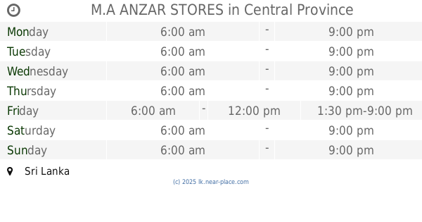
M.A ANZAR STORES
Sri Lanka
Supermarket
read more
📑
all categories
Accounting
Administrative area level 1
Administrative area level 2
Airport
Amusement park
Aquarium
Art gallery
Atm
Bakery
Bank
Bar
Beauty salon
Bicycle store
Book store
Bowling alley
Bus station
Cafe
Campground
Car dealer
Car rental
Car repair
Car wash
Casino
Cemetery
Church
City hall
Clothing store
Colloquial area
Convenience store
Country
Courthouse
Dentist
Department store
Doctor
Electrician
Electronics store
Embassy
Finance
Fire station
Florist
Food
Funeral home
Furniture store
Gas station
General contractor
Grocery or supermarket
Gym
Hair care
Hardware store
Health
Hindu Temple
Home goods store
Hospital
Insurance agency
Intersection
Jewelry store
Laundry
Lawyer
Library
Light rail station
Liquor store
Local government office
Locality
Locksmith
Lodging
Meal delivery
Meal takeaway
Mosque
Movie rental
Movie theater
Moving company
Museum
Natural feature
Neighborhood
Night club
Painter
Park
Parking
Pet store
Pharmacy
Physiotherapist
Place of worship
Plumber
Point of interest
Police
Political
Post office
Premise
Real estate agency
Restaurant
Roofing contractor
Route
Rv park, camping
School
Shoe store
Shopping mall
Spa
Stadium
Storage
Store
Subpremise
Supermarket
Synagogue
Taxi stand
Train station
Transit station
Travel agency
University
Veterinary care
Zoo
administrative area level 3
sublocality level 1
sublocality level 2
↑