Train station nearby Aluthgama Railway Station
Sri Lanka
Train station nearby Aluthgama Railway Station
Aluthgama Railway Station
Aluthgama, Sri Lanka
contacts phone
:
+94 342 275 282
website:
www.railway.gov.lk
Latitude:
6.4329486
, Longitude:
80.0002849
larger map & directions
read more
nearest Train station
1.265 km
Bentota
Railway Station Road, Wadduwa
Train station
read more
2.984 km
Hettimulla Railway Station
Hettimulla, Beruwala
Train station
read more
5.134 km
Induruwa Railway Station
Colombo-Galle-Hambantota-Wellawaya Highway, Induruwa
Train station
read more
5.228 km
Beruwala Railway station
Beruwala
Train station
read more
7.79 km
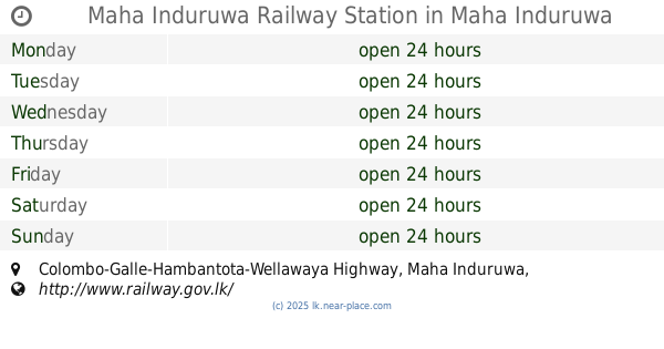
Maha Induruwa Railway Station
Colombo-Galle-Hambantota-Wellawaya Highway, Maha Induruwa
Train station
read more
8.257 km
Maggona
A2, Maggona
Train station
read more
10.146 km
Paya South
Galle Road , payagala south, Galle Road
Train station
read more
10.146 km
Paya South
Galle Road , payagala south, Galle Rd
Train station
read more
10.992 km
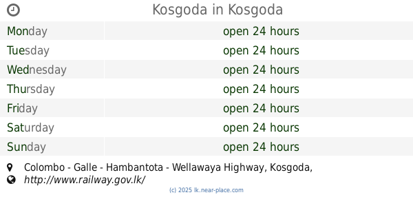
Kosgoda
A2, Kosgoda
Train station
read more
11.318 km
Payagala North Railway Station
Payagala north, Payagala.
Train station
read more
13.994 km
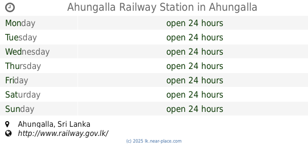
Ahungalla Railway Station
Ahungalla
Train station
read more
14.631 km
Katukurunda Railway Station
Station Road, Kalutara
Train station
read more
15.85 km
Pathegamgoda
Madhuwa Road, Balapitiya
Train station
read more
17.415 km
Kalutara South
Station Road, Kalutara
Train station
read more
19.255 km
Andadola Station
Berathuduwa Road, Balapitiya
Train station
read more
19.385 km
Railway Station Kalutara North
Wadduwa
Train station
read more
21.144 km
Kandegoda Railway Station
B14, Ambalangoda
Train station
read more
21.144 km
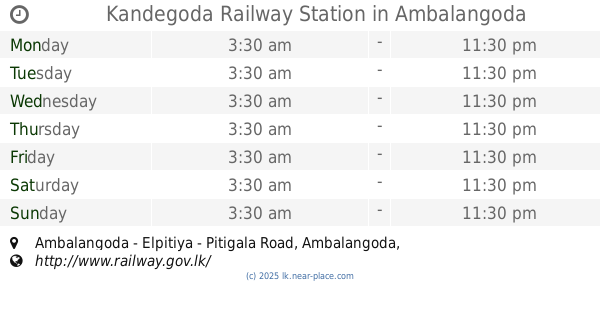
Kandegoda Railway Station
Ambalangoda - Elpitiya - Pitigala Road, Ambalangoda
Train station
read more
22.795 km
Ambalangoda Railway Station
A2, Ambalangoda
Train station
read more
23.153 km
No 01 Railway Station
Pothupitiya West, Waskaduwa
Train station
read more
28.937 km
Kahawe
A2, Kahawa
Train station
read more
29.631 km
Pinwatta Railway Station
Panadura
Train station
read more
36.485 km
Egoda Uyana Railway Station
Moratuwa
Train station
read more
39.996 km
Dodanduwa Railway Station
A2, Dodanduwa
Train station
read more
51.484 km
Gammana Halt (Pinnawala)
Train station
read more
📑
all categories
Accounting
Administrative area level 1
Administrative area level 2
Airport
Amusement park
Aquarium
Art gallery
Atm
Bakery
Bank
Bar
Beauty salon
Bicycle store
Book store
Bowling alley
Bus station
Cafe
Campground
Car dealer
Car rental
Car repair
Car wash
Casino
Cemetery
Church
City hall
Clothing store
Colloquial area
Convenience store
Country
Courthouse
Dentist
Department store
Doctor
Electrician
Electronics store
Embassy
Finance
Fire station
Florist
Food
Funeral home
Furniture store
Gas station
General contractor
Grocery or supermarket
Gym
Hair care
Hardware store
Health
Hindu Temple
Home goods store
Hospital
Insurance agency
Intersection
Jewelry store
Laundry
Lawyer
Library
Light rail station
Liquor store
Local government office
Locality
Locksmith
Lodging
Meal delivery
Meal takeaway
Mosque
Movie rental
Movie theater
Moving company
Museum
Natural feature
Neighborhood
Night club
Painter
Park
Parking
Pet store
Pharmacy
Physiotherapist
Place of worship
Plumber
Point of interest
Police
Political
Post office
Premise
Real estate agency
Restaurant
Roofing contractor
Route
Rv park, camping
School
Shoe store
Shopping mall
Spa
Stadium
Storage
Store
Subpremise
Supermarket
Synagogue
Taxi stand
Train station
Transit station
Travel agency
University
Veterinary care
Zoo
administrative area level 3
sublocality level 1
sublocality level 2
↑