Food nearby Fish Land Farm
Coronavirus disease (COVID-19) Situation
confirmed cases
672754
deaths
16897
Sri Lanka
Food nearby Fish Land Farm
Fish Land Farm
School Lane, Pethiyagoda, Gampaha, LK Sri Lanka
contacts phone
:
+94
Latitude:
7.144419
, Longitude:
79.991439
larger map & directions
read more
nearest Food
627 m
kanchana Storse
31 A, 31 A B225
Food
read more
1.571 km
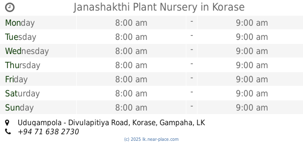
Janashakthi Plant Nursery
Udugampola - Divulapitiya Road, Korase
Food
read more
3.128 km
Milk Collection Centre
Fonterra Brands Lanka - GMCC, Doranagoda Rd
Food
read more
3.533 km
Ranbima Dairies
Essella para
Food
read more
3.679 km
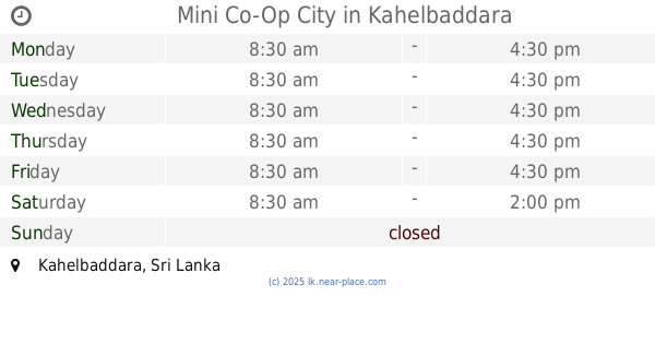
Mini Co-Op City
Kahelbaddara
Food
read more
3.72 km
Ravidu Cashew (රවිදු කජු සල)
Kahelbaddara
Food
read more
4.603 km
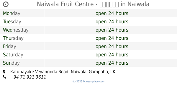
Naiwala Fruit Centre - පලතුරු
Katunayake-Veyangoda Road, Naiwala
Food
read more
4.61 km
Vithana Cashew
Batapotha
Food
read more
4.633 km
Rathnasiri Stores - රත්නසිරි ස්ටෝර්ස් - නයිවල
Naiwala Junction, Veyangoda
Food
read more
4.71 km
NuwanHunter
Gampaha
Food
read more
4.913 km
Nethmi Foods Centre
No : 149/3, Aluthgama
Food
read more
5.28 km
asiri food factory
Nedagamuwa
Food
read more
5.577 km
SBK Gram Stores
Minuwangoda
Food
read more
5.747 km
RKR Vegetable
Makewita Road
Food
read more
5.809 km
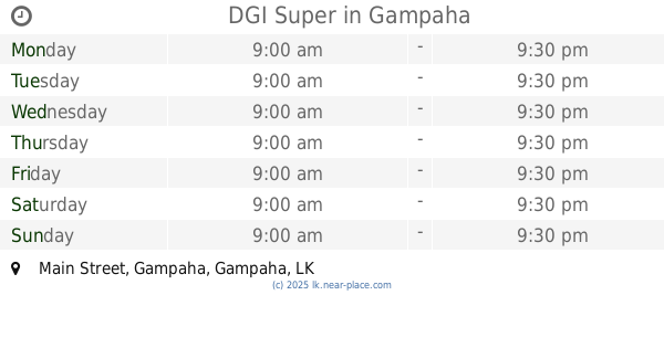
DGI Super
Main Street, Gampaha
Food
read more
6.679 km
Royal Cashew Factory
Sri Lanka
Food
read more
7.574 km
Sandathilina Stores
Kalagedihena
Food
read more
9.495 km
Feed Caterers
Gampaha
Food
read more
11.835 km
Pradeep Store
Baseline Road, Seeduwa
Food
read more
12.491 km
JanRich Foods Ltd
Wathupitiwela Kiththammahara Road, Wathupitiwala
Food
read more
12.98 km
ALNA WATER SYSTEM (PVT) LTD.
No202, Embaraluwa North 2, Weliweriya
Food
read more
14.656 km
Ranji Vegetables
Veyangoda
Food
read more
15.226 km
Lal poultry Farm
Ruwanpura Kanattha Road
Food
read more
17.734 km
Ashraf Gass and Water Supplier
Negombo
Food
read more
17.748 km
ILONKA ILONKA
Negombo - Mirigama Road, Mirigama
Food
read more
📑
all categories
Accounting
Administrative area level 1
Administrative area level 2
Airport
Amusement park
Aquarium
Art gallery
Atm
Bakery
Bank
Bar
Beauty salon
Bicycle store
Book store
Bowling alley
Bus station
Cafe
Campground
Car dealer
Car rental
Car repair
Car wash
Casino
Cemetery
Church
City hall
Clothing store
Colloquial area
Convenience store
Country
Courthouse
Dentist
Department store
Doctor
Electrician
Electronics store
Embassy
Finance
Fire station
Florist
Food
Funeral home
Furniture store
Gas station
General contractor
Grocery or supermarket
Gym
Hair care
Hardware store
Health
Hindu Temple
Home goods store
Hospital
Insurance agency
Intersection
Jewelry store
Laundry
Lawyer
Library
Light rail station
Liquor store
Local government office
Locality
Locksmith
Lodging
Meal delivery
Meal takeaway
Mosque
Movie rental
Movie theater
Moving company
Museum
Natural feature
Neighborhood
Night club
Painter
Park
Parking
Pet store
Pharmacy
Physiotherapist
Place of worship
Plumber
Point of interest
Police
Political
Post office
Premise
Real estate agency
Restaurant
Roofing contractor
Route
Rv park, camping
School
Shoe store
Shopping mall
Spa
Stadium
Storage
Store
Subpremise
Supermarket
Synagogue
Taxi stand
Train station
Transit station
Travel agency
University
Veterinary care
Zoo
administrative area level 3
sublocality level 1
sublocality level 2
↑