Food nearby Lal poultry Farm
Coronavirus disease (COVID-19) Situation
confirmed cases
672754
deaths
16897
Sri Lanka
Food nearby Lal poultry Farm
Lal poultry Farm
Ruwanpura Kanattha Road, Gampaha, Western Province, LK Sri Lanka
contacts phone
:
+94
Latitude:
7.0793527
, Longitude:
80.1128818
larger map & directions
read more
nearest Food
766 m
Rice Mill
Sri Lanka
Food
read more
1.262 km
Kularathne Grinding Mills
Opathella Road
Food
read more
1.502 km
N M Samith Palace Palace
129 Main Street - Kahatowita, Kahatowita
Food
read more
1.94 km
Dikkanda Plantation (Pvt) Ltd.
Sri Lanka
Food
read more
2.508 km
Dikpatiya
Wathurugama
Food
read more
3.956 km
Polwattha Stores
B416, Kalagedihena
Food
read more
4.04 km
MD Manufacturing Plant
B18
Food
read more
4.083 km
Vege Hut Urapola
290 Nittambuwa - Ruwanwella Road, Urapola
Food
read more
4.359 km
Kuliyapitiya Rice Mill
Raja Weediya
Food
read more
4.44 km
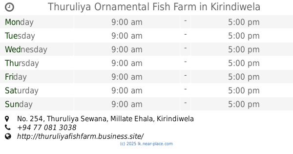
Thuruliya Ornamental Fish Farm
No. 254, Thuruliya Sewana, Millate Ehala, Kirindiwela
Food
read more
4.481 km
Acqua Pet Lanka
282 B19, Urapola
Food
read more
4.7 km
JanRich Foods Ltd
Wathupitiwela Kiththammahara Road, Wathupitiwala
Food
read more
5.401 km
Rasoja Food Products (Pvt) Ltd.
Wathupitiwala - Maimbula - Ellakkala Road, Wathupitiwala
Food
read more
5.775 km
Ilma Catering Service
Kalagedihena
Food
read more
7.14 km
Feed Caterers
Gampaha
Food
read more
7.653 km
Sandathilina Stores
Kalagedihena
Food
read more
10.675 km
Weliveriya Fish Market
Weliveriya, Pinco Watta Road, Weliweriya
Food
read more
10.916 km
Ranji Vegetables
Veyangoda
Food
read more
13.208 km
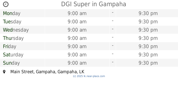
DGI Super
Main Street, Gampaha
Food
read more
13.225 km
ALNA WATER SYSTEM (PVT) LTD.
No202, Embaraluwa North 2, Weliweriya
Food
read more
14.997 km
Asiri Gram Center
Sri Lanka
Food
read more
15.026 km
Devimi Stores
Sri Lanka
Food
read more
15.226 km
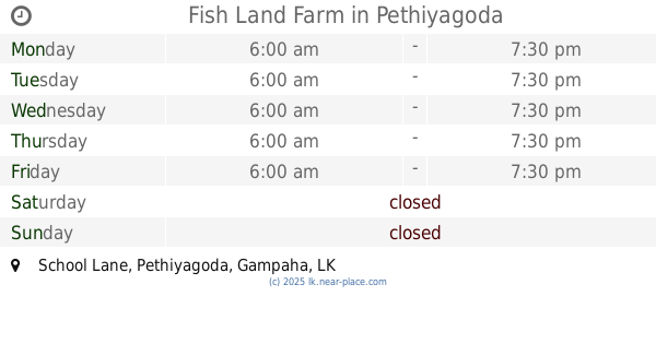
Fish Land Farm
School Lane, Pethiyagoda
Food
read more
15.728 km
kanchana Storse
31 A, 31 A B225
Food
read more
18.098 km
Premiere One Water Systems (Pvt) Ltd
Sri Lanka
Food
read more
📑
all categories
Accounting
Administrative area level 1
Administrative area level 2
Airport
Amusement park
Aquarium
Art gallery
Atm
Bakery
Bank
Bar
Beauty salon
Bicycle store
Book store
Bowling alley
Bus station
Cafe
Campground
Car dealer
Car rental
Car repair
Car wash
Casino
Cemetery
Church
City hall
Clothing store
Colloquial area
Convenience store
Country
Courthouse
Dentist
Department store
Doctor
Electrician
Electronics store
Embassy
Finance
Fire station
Florist
Food
Funeral home
Furniture store
Gas station
General contractor
Grocery or supermarket
Gym
Hair care
Hardware store
Health
Hindu Temple
Home goods store
Hospital
Insurance agency
Intersection
Jewelry store
Laundry
Lawyer
Library
Light rail station
Liquor store
Local government office
Locality
Locksmith
Lodging
Meal delivery
Meal takeaway
Mosque
Movie rental
Movie theater
Moving company
Museum
Natural feature
Neighborhood
Night club
Painter
Park
Parking
Pet store
Pharmacy
Physiotherapist
Place of worship
Plumber
Point of interest
Police
Political
Post office
Premise
Real estate agency
Restaurant
Roofing contractor
Route
Rv park, camping
School
Shoe store
Shopping mall
Spa
Stadium
Storage
Store
Subpremise
Supermarket
Synagogue
Taxi stand
Train station
Transit station
Travel agency
University
Veterinary care
Zoo
administrative area level 3
sublocality level 1
sublocality level 2
↑