Food nearby Weliveriya Fish Market
Coronavirus disease (COVID-19) Situation
confirmed cases
672754
deaths
16897
Sri Lanka
Food nearby Weliveriya Fish Market
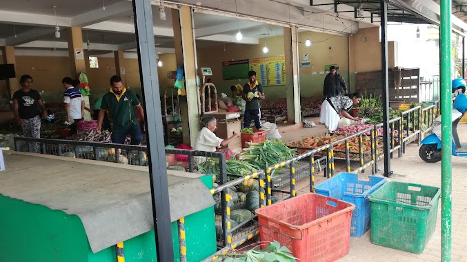
Weliveriya Fish Market
Pinco Watta Road, Weliweriya, Sri Lanka
contacts phone
:
+94
Latitude:
7.031624
, Longitude:
80.0289343
larger map & directions
read more
nearest Food
67 m
Sathosa
Weliweriya East, Weliweriya
Food
read more
298 m
Gauri Catering
Hellanwatta Road, Weliweriya
Food
read more
737 m
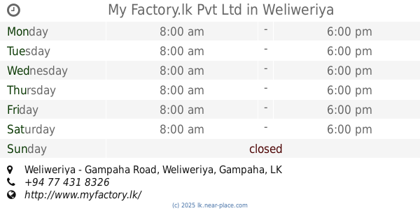
My Factory.lk Pvt Ltd
Weliweriya - Gampaha Road, Weliweriya
Food
read more
1.045 km
J And S Fruits
Embaraluwa South1
Food
read more
1.077 km
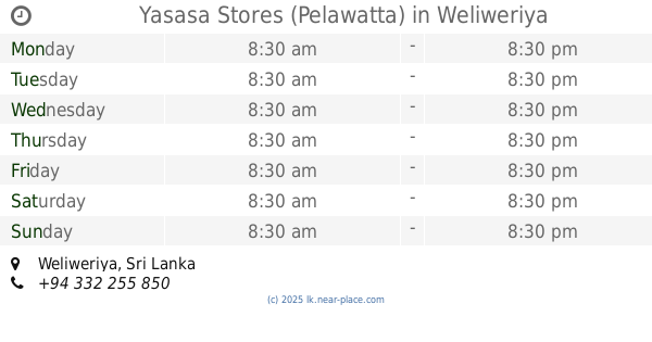
Yasasa Stores (Pelawatta)
Weliweriya
Food
read more
2.004 km
Western Lanka Fisherie
75 Henegama
Food
read more
2.712 km
ALNA WATER SYSTEM (PVT) LTD.
No202, Embaraluwa North 2, Weliweriya
Food
read more
2.798 km
Agri Ice Cream
Embaraluwa South2
Food
read more
2.858 km
Baurs
Sri Lanka
Food
read more
3.743 km
Amil's Fruits Zone
No: 66/13, Walawwaththa, Belummahara, Mudungoda, B214
Food
read more
3.743 km
Amil's Fruits Zone
No: 66/13, Walawwaththa, Belummahara, Mudungoda, New Kandy Road
Food
read more
4.275 km
Siyane Communication
Mudungoda
Food
read more
4.28 km
Karunarathna Stores
14, Makola - Udupila Road
Food
read more
4.385 km
Dammika Stores
Akurumulla
Food
read more
4.438 km
Udupila Fair
Udupila South 67/2 New Kandy Road
Food
read more
4.556 km
Nishantha Mills
82 C1 Webada Road
Food
read more
4.644 km
Asiri Gram Center
Food
read more
4.849 km
Laksanda Vegetable Shop
දෙල්ගොඩ
Food
read more
4.894 km
Pussalla Meat Shop
Minuwangoda-Gampaha-Miriswatta Road, Gampaha
Food
read more
5.214 km
Asiri Gram Center
Sri Lanka
Food
read more
5.236 km
Devimi Stores
Sri Lanka
Food
read more
5.314 km
Udumbara Caterers
Gampaha
Food
read more
5.795 km
Star Foods
165/F,, Orutota Road, Gampaha
Food
read more
10.675 km
Lal poultry Farm
Ruwanpura Kanattha Road
Food
read more
14.61 km
දිල්හානි ෆෘට් සෙන්ටර්
173 Biyagama Road, Peliyagoda
Food
read more
📑
all categories
Accounting
Administrative area level 1
Administrative area level 2
Airport
Amusement park
Aquarium
Art gallery
Atm
Bakery
Bank
Bar
Beauty salon
Bicycle store
Book store
Bowling alley
Bus station
Cafe
Campground
Car dealer
Car rental
Car repair
Car wash
Casino
Cemetery
Church
City hall
Clothing store
Colloquial area
Convenience store
Country
Courthouse
Dentist
Department store
Doctor
Electrician
Electronics store
Embassy
Finance
Fire station
Florist
Food
Funeral home
Furniture store
Gas station
General contractor
Grocery or supermarket
Gym
Hair care
Hardware store
Health
Hindu Temple
Home goods store
Hospital
Insurance agency
Intersection
Jewelry store
Laundry
Lawyer
Library
Light rail station
Liquor store
Local government office
Locality
Locksmith
Lodging
Meal delivery
Meal takeaway
Mosque
Movie rental
Movie theater
Moving company
Museum
Natural feature
Neighborhood
Night club
Painter
Park
Parking
Pet store
Pharmacy
Physiotherapist
Place of worship
Plumber
Point of interest
Police
Political
Post office
Premise
Real estate agency
Restaurant
Roofing contractor
Route
Rv park, camping
School
Shoe store
Shopping mall
Spa
Stadium
Storage
Store
Subpremise
Supermarket
Synagogue
Taxi stand
Train station
Transit station
Travel agency
University
Veterinary care
Zoo
administrative area level 3
sublocality level 1
sublocality level 2
↑