Cafe nearby Central Palace
Sri Lanka
Cafe nearby Central Palace
Central Palace
Dematagoda Road, 00900, Colombo, Colombo, LK Sri Lanka
contacts phone
:
+94
Latitude:
6.931821
, Longitude:
79.875936
larger map & directions
read more
nearest Cafe
358 m
Mathara Isuru Hotel
54/1, බේස්ලයින් පාර, කොළඹ
Cafe
read more
383 m
Ranfer Group
No: 36 Ketawalamulla Place (off Siri Dhamma Mawatha), Colombo 09, Colombo
Cafe
read more
591 m
Mac Cafe
327 North M. Ishak Mawatha, Colombo
Cafe
read more
625 m
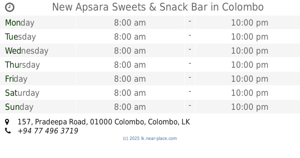
New Apsara Sweets & Snack Bar
157 Pradeepa Road, Colombo
Cafe
read more
659 m
Gurusinghe palace
609 Doctor Danister De Silva Mawatha, Colombo
Cafe
read more
928 m
sivan Kafe
No: 283, Road, 9, කොළඹ
Cafe
read more
965 m
Cannys Bakers
Colombo
Cafe
read more
1.002 km
Highland Sales Outlet Pension Department
Sevana Mawatha, Colombo
Cafe
read more
1.007 km
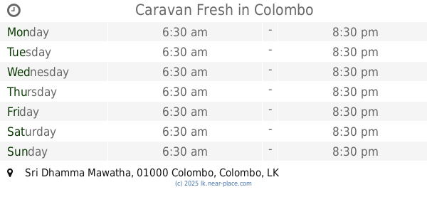
Caravan Fresh
Sri Dhamma Mawatha, Colombo
Cafe
read more
1.034 km
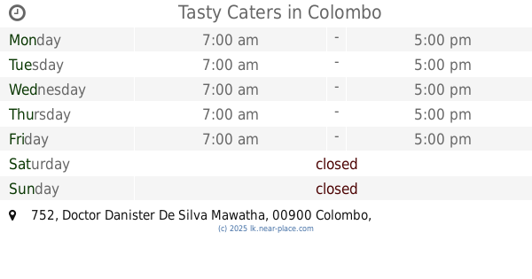
Tasty Caters
752 Doctor Danister De Silva Mawatha, Colombo
Cafe
read more
1.181 km
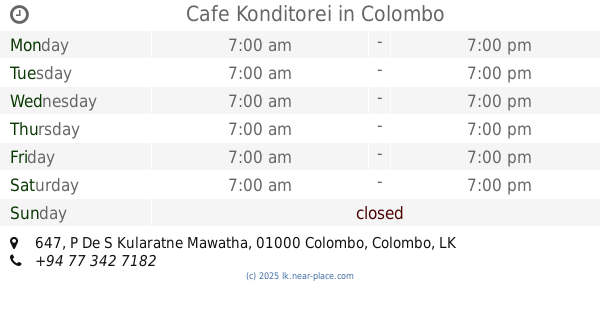
Cafe Konditorei
647 P De S Kularatne Mawatha, Colombo
Cafe
read more
1.322 km
Hotel De Excellent
Colombo
Cafe
read more
1.355 km
orugodawaththa
AC19, Colombo
Cafe
read more
1.581 km
R.N.R. Cool Corner
Sri Sumanatissa Mawatha, Colombo
Cafe
read more
1.614 km
Trace Expert City Cafeteria
McCallum Road, Colombo
Cafe
read more
1.619 km
Perera & Sons
McCallum Road, Colombo
Cafe
read more
1.634 km
Perera & Sons
203 De Saram Place, Colombo
Cafe
read more
1.655 km
Ss. Cafe
Cafe
read more
1.707 km
Caravan Fresh
Colombo
Cafe
read more
1.923 km
T.N Cafe
Colombo
Cafe
read more
2.051 km
Techno Cafe
475 Union Place, Colombo
Cafe
read more
2.128 km
Tea'amo Exports (Pvt) Ltd
27 Rosmead Place, Colombo 07
Cafe
read more
2.278 km
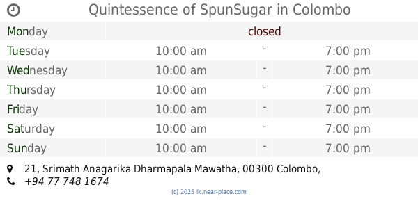
Quintessence of SpunSugar
21 Srimath Anagarika Dharmapala Mawatha, Colombo
Cafe
read more
2.344 km
Kotahena Cream House
71 Bonjeen Road, Colombo
Cafe
read more
2.646 km
Rancrisp Cashew
145 Srimath Anagarika Dharmapala Mawatha, Colombo
Cafe
read more
📑
all categories
Accounting
Administrative area level 1
Administrative area level 2
Airport
Amusement park
Aquarium
Art gallery
Atm
Bakery
Bank
Bar
Beauty salon
Bicycle store
Book store
Bowling alley
Bus station
Cafe
Campground
Car dealer
Car rental
Car repair
Car wash
Casino
Cemetery
Church
City hall
Clothing store
Colloquial area
Convenience store
Country
Courthouse
Dentist
Department store
Doctor
Electrician
Electronics store
Embassy
Finance
Fire station
Florist
Food
Funeral home
Furniture store
Gas station
General contractor
Grocery or supermarket
Gym
Hair care
Hardware store
Health
Hindu Temple
Home goods store
Hospital
Insurance agency
Intersection
Jewelry store
Laundry
Lawyer
Library
Light rail station
Liquor store
Local government office
Locality
Locksmith
Lodging
Meal delivery
Meal takeaway
Mosque
Movie rental
Movie theater
Moving company
Museum
Natural feature
Neighborhood
Night club
Painter
Park
Parking
Pet store
Pharmacy
Physiotherapist
Place of worship
Plumber
Point of interest
Police
Political
Post office
Premise
Real estate agency
Restaurant
Roofing contractor
Route
Rv park, camping
School
Shoe store
Shopping mall
Spa
Stadium
Storage
Store
Subpremise
Supermarket
Synagogue
Taxi stand
Train station
Transit station
Travel agency
University
Veterinary care
Zoo
administrative area level 3
sublocality level 1
sublocality level 2
↑