Cafe nearby Mac Cafe
Sri Lanka
Cafe nearby Mac Cafe
Mac Cafe
327 North M. Ishak Mawatha, Colombo Sri Lanka
contacts phone
:
+94
Latitude:
6.9298731
, Longitude:
79.870956
read more
nearest Cafe
303 m
Ranfer Group
No: 36 Ketawalamulla Place (off Siri Dhamma Mawatha), Colombo 09, Colombo
Cafe
read more
339 m
sivan Kafe
No: 283, Road, 9, කොළඹ
Cafe
read more
513 m
Highland Sales Outlet Pension Department
Sevana Mawatha, Colombo
Cafe
read more
591 m
Central Palace
No: 536, Dematagoda Road, Colombo
Cafe
read more
593 m
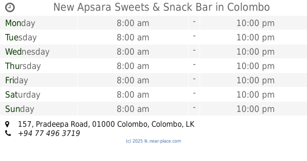
New Apsara Sweets & Snack Bar
157 Pradeepa Road, Colombo
Cafe
read more
645 m
Wasana bakers Colombo
Sri Vajiragnana Mawatha, Colombo
Cafe
read more
651 m
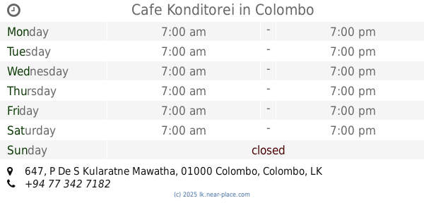
Cafe Konditorei
647 P De S Kularatne Mawatha, Colombo
Cafe
read more
652 m
New Bombay Sweet
Colombo
Cafe
read more
700 m
Rizvi Snacks
Ven Baddegama Wimalawansa Mawatha, Colombo
Cafe
read more
714 m
Beruwala Eating House
Ven Baddegama Wimalawansa Mawatha, Colombo
Cafe
read more
714 m
Ibrahim Eating House
Ven Baddegama Wimalawansa Mawatha, Colombo
Cafe
read more
733 m
Hotel De Excellent
Colombo
Cafe
read more
768 m
orugodawaththa
AC19, Colombo
Cafe
read more
779 m
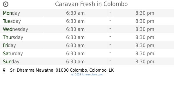
Caravan Fresh
Sri Dhamma Mawatha, Colombo
Cafe
read more
788 m
Mathara Isuru Hotel
54/1, බේස්ලයින් පාර, කොළඹ
Cafe
read more
810 m
Game Aholic
Mohideen Masjid Road, Colombo
Cafe
read more
856 m
Madampa Caterers
Colombo
Cafe
read more
898 m
Euphorium Tea Salon
Colombo
Cafe
read more
993 m
Vijeyananda Hotel
Sri Sangaraja Mawatha, Colombo
Cafe
read more
1.025 km
Tea Breeze (Pvt)Ltd
No: 97, Ananda Rajakaruna Mawatha
Cafe
read more
1.044 km
Cannys Bakers
Colombo
Cafe
read more
1.104 km
Gurusinghe palace
609 Doctor Danister De Silva Mawatha, Colombo
Cafe
read more
1.177 km
The Waffle Inc.
57 Vinayalankara Mawatha, Colombo
Cafe
read more
1.204 km
Supun Snack Bar
111 Vinayalankara Mawatha, Colombo
Cafe
read more
1.368 km
T.N Cafe
Colombo
Cafe
read more
📑
all categories
Accounting
Administrative area level 1
Administrative area level 2
Airport
Amusement park
Aquarium
Art gallery
Atm
Bakery
Bank
Bar
Beauty salon
Bicycle store
Book store
Bowling alley
Bus station
Cafe
Campground
Car dealer
Car rental
Car repair
Car wash
Casino
Cemetery
Church
City hall
Clothing store
Colloquial area
Convenience store
Country
Courthouse
Dentist
Department store
Doctor
Electrician
Electronics store
Embassy
Finance
Fire station
Florist
Food
Funeral home
Furniture store
Gas station
General contractor
Grocery or supermarket
Gym
Hair care
Hardware store
Health
Hindu Temple
Home goods store
Hospital
Insurance agency
Intersection
Jewelry store
Laundry
Lawyer
Library
Light rail station
Liquor store
Local government office
Locality
Locksmith
Lodging
Meal delivery
Meal takeaway
Mosque
Movie rental
Movie theater
Moving company
Museum
Natural feature
Neighborhood
Night club
Painter
Park
Parking
Pet store
Pharmacy
Physiotherapist
Place of worship
Plumber
Point of interest
Police
Political
Post office
Premise
Real estate agency
Restaurant
Roofing contractor
Route
Rv park, camping
School
Shoe store
Shopping mall
Spa
Stadium
Storage
Store
Subpremise
Supermarket
Synagogue
Taxi stand
Train station
Transit station
Travel agency
University
Veterinary care
Zoo
administrative area level 3
sublocality level 1
sublocality level 2
↑