Cafe nearby Jasantha Cafee
Sri Lanka
Cafe nearby Jasantha Cafee
Jasantha Cafee
Hakmana - Beliatte - Tangalle Road, Hakmana Sri Lanka
contacts phone
:
+94
Latitude:
6.077835
, Longitude:
80.676883
read more
nearest Cafe
4.908 km
Sumudu Cafe
Hakmana - Beliatte - Tangalle Road
Cafe
read more
8.966 km
Nihal Cafe
Walasmulla
Cafe
read more
9.474 km
ruwan stors
Dewalegama Road, Walasmulla
Cafe
read more
11.676 km
damithtravels
Wellawatta - Pahalagoda Road, Kudawella
Cafe
read more
12.611 km
Pathirana Shop
シハゴダ - カンバーウピティヤ=マワララ=コタポラ・ロード
Cafe
read more
12.764 km
Dots Surf Cafe
Nilwella Road, Dickwella
Cafe
read more
13.001 km
Verse Collective
Pehebiya Road
Cafe
read more
13.744 km
Chinese Hotel
Hakmana, Sri Hemaloka Mawatha, Mulatiyana
Cafe
read more
13.754 km
Brothers Restaurant
Hakmana, Sri Hemaloka Mawatha, Mulatiyana
Cafe
read more
14.102 km
Prassanna Restaurant & Cool Spot
Tangalle
Cafe
read more
14.444 km
Ceylon Sea Hotel
6.030990, 80.798629, Medaketiya Road
Cafe
read more
14.444 km
Ceylon Sea Hotel
6.030990, 80.798629, Medaketiya Road, Tangalle
Cafe
read more
14.596 km
Golden Surfer
82200, Medaketiya
Cafe
read more
15.434 km
VTA Cafe
Talalla
Cafe
read more
18.308 km
Armbawatta Kade
Sri Lanka
Cafe
read more
18.349 km
Kopi Kade
Sri Lanka
Cafe
read more
19.247 km
Ranjani Cafe
welewatta,matara
Cafe
read more
20.02 km
FA Hotel
A2, Matara
Cafe
read more
20.101 km
D.E.N. New Jayasiri Hotel
Matara
Cafe
read more
20.396 km
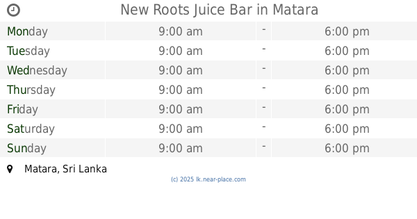
New Roots Juice Bar
Matara
Cafe
read more
20.508 km
Leela Cool Spot
Beach Road, Matara
Cafe
read more
20.555 km
Nuga Sewana Foods
Anagarika Dharmapala Mawatha, Matara
Cafe
read more
20.555 km
Nuga Sewana Foods
B535, Matara
Cafe
read more
20.657 km
Mahen graphics & Advertising (PC)
Bathuta Road, Matara
Cafe
read more
20.673 km
Harishchandra Cafe
Nilwala By pass, Matara
Cafe
read more
📑
all categories
Accounting
Administrative area level 1
Administrative area level 2
Airport
Amusement park
Aquarium
Art gallery
Atm
Bakery
Bank
Bar
Beauty salon
Bicycle store
Book store
Bowling alley
Bus station
Cafe
Campground
Car dealer
Car rental
Car repair
Car wash
Casino
Cemetery
Church
City hall
Clothing store
Colloquial area
Convenience store
Country
Courthouse
Dentist
Department store
Doctor
Electrician
Electronics store
Embassy
Finance
Fire station
Florist
Food
Funeral home
Furniture store
Gas station
General contractor
Grocery or supermarket
Gym
Hair care
Hardware store
Health
Hindu Temple
Home goods store
Hospital
Insurance agency
Intersection
Jewelry store
Laundry
Lawyer
Library
Light rail station
Liquor store
Local government office
Locality
Locksmith
Lodging
Meal delivery
Meal takeaway
Mosque
Movie rental
Movie theater
Moving company
Museum
Natural feature
Neighborhood
Night club
Painter
Park
Parking
Pet store
Pharmacy
Physiotherapist
Place of worship
Plumber
Point of interest
Police
Political
Post office
Premise
Real estate agency
Restaurant
Roofing contractor
Route
Rv park, camping
School
Shoe store
Shopping mall
Spa
Stadium
Storage
Store
Subpremise
Supermarket
Synagogue
Taxi stand
Train station
Transit station
Travel agency
University
Veterinary care
Zoo
administrative area level 3
sublocality level 1
sublocality level 2
↑