Cafe nearby Jeevani Bakery
Sri Lanka
Cafe nearby Jeevani Bakery
Jeevani Bakery
340, Biyagama Road, Peliyagoda, Colombo, LK Sri Lanka
contacts phone
:
+94
Latitude:
6.9508599
, Longitude:
79.911483
larger map & directions
read more
nearest Cafe
550 m
Upul Bakery
61, Kuda Buthgamuwa Road, Angoda
Cafe
read more
972 m
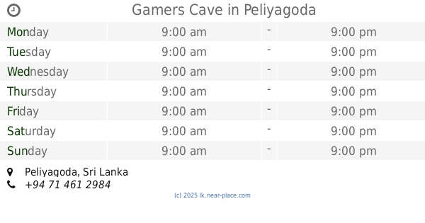
Gamers Cave
Peliyagoda
Cafe
read more
1.13 km
Bread Chief Bakery
Nungamugoda Road, Peliyagoda
Cafe
read more
1.331 km
Hot Hot Soup
Biyagama Road, Peliyagoda
Cafe
read more
1.571 km
Classic Teas (Pvt) Ltd
Peliyagoda
Cafe
read more
1.636 km
Thambapanni Tea (Pvt) Ltd
No 75, Avissawella Road< Mahabuthgamuwa, Angoda
Cafe
read more
1.733 km
Flavours
Peliyagoda Pattiya East, Peliyagoda
Cafe
read more
1.81 km
Come to My Home
No 252/4A, Avissawella Road, Wellampitiya
Cafe
read more
1.915 km
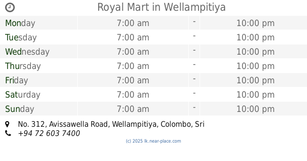
Royal Mart
No. 312, Avissawella Road, Wellampitiya, Colombo, Sri Lanka, Wellampitiya
Cafe
read more
1.978 km
MR.RICE
Gonawala West, Peliyagoda
Cafe
read more
2.215 km
R & D Cafe
Pattiya West, Peliyagoda
Cafe
read more
2.249 km
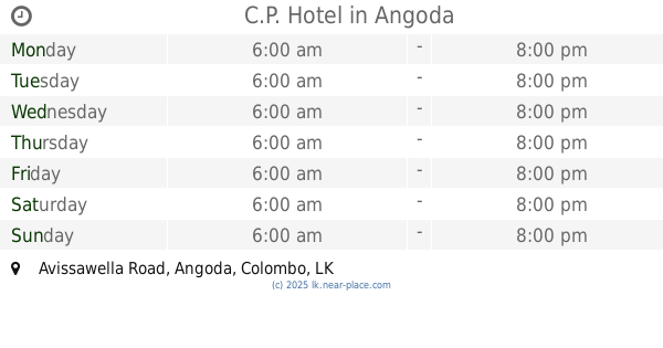
C.P. Hotel
Avissawella Road, Angoda
Cafe
read more
2.268 km
Isuru Tasty Shop
309/C Siri Sumana Mawatha, Angoda
Cafe
read more
2.273 km
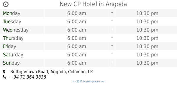
New CP Hotel
Super Market, 13, Buthgamuwa Road, Angoda
Cafe
read more
2.369 km
Jayam Those Cafe
Megoda Kolonnawa
Cafe
read more
2.381 km
Dinesha Rasahala
A1, Wattala
Cafe
read more
2.737 km
Unity The Game Station
B231, Kotikawatta
Cafe
read more
2.745 km
Udaya karunaratne
33 Lumbini Mawatha
Cafe
read more
2.83 km
Hilton Canteen
Sarasavi Mawatha, Dalugama
Cafe
read more
2.842 km
Milk Bar
Sarasavi Mawatha, Dalugama
Cafe
read more
2.941 km
Pizza Hut
228A1/1 Colombo - Kandy Road
Cafe
read more
3.08 km
Hot Tea
Wanawasala - Wattala Road, Wattala
Cafe
read more
3.174 km
Thish plaza
Meegahawatta Road, Wattala
Cafe
read more
3.373 km
St. Anthony's Food
60/1 Kandy Road, Kiribathgoda
Cafe
read more
3.538 km
trianglepix Gallery
Wattala
Cafe
read more
📑
all categories
Accounting
Administrative area level 1
Administrative area level 2
Airport
Amusement park
Aquarium
Art gallery
Atm
Bakery
Bank
Bar
Beauty salon
Bicycle store
Book store
Bowling alley
Bus station
Cafe
Campground
Car dealer
Car rental
Car repair
Car wash
Casino
Cemetery
Church
City hall
Clothing store
Colloquial area
Convenience store
Country
Courthouse
Dentist
Department store
Doctor
Electrician
Electronics store
Embassy
Finance
Fire station
Florist
Food
Funeral home
Furniture store
Gas station
General contractor
Grocery or supermarket
Gym
Hair care
Hardware store
Health
Hindu Temple
Home goods store
Hospital
Insurance agency
Intersection
Jewelry store
Laundry
Lawyer
Library
Light rail station
Liquor store
Local government office
Locality
Locksmith
Lodging
Meal delivery
Meal takeaway
Mosque
Movie rental
Movie theater
Moving company
Museum
Natural feature
Neighborhood
Night club
Painter
Park
Parking
Pet store
Pharmacy
Physiotherapist
Place of worship
Plumber
Point of interest
Police
Political
Post office
Premise
Real estate agency
Restaurant
Roofing contractor
Route
Rv park, camping
School
Shoe store
Shopping mall
Spa
Stadium
Storage
Store
Subpremise
Supermarket
Synagogue
Taxi stand
Train station
Transit station
Travel agency
University
Veterinary care
Zoo
administrative area level 3
sublocality level 1
sublocality level 2
↑