Cafe nearby Livestock Breedes Co-op Society
Sri Lanka
Cafe nearby Livestock Breedes Co-op Society
Livestock Breedes Co-op Society
Aninchiyan Kulam, Mallavi Sri Lanka
contacts phone
:
+94
Latitude:
9.137417
, Longitude:
80.307869
read more
nearest Cafe
6.423 km
Kopu
Cafe
read more
40.688 km
Maniyam Sharbat
Udaiyaarkaddu
Cafe
read more
42.134 km
New niron hotel
Pooneryn
Cafe
read more
42.14 km
Nilavan Hotel
Pooneryn
Cafe
read more
43.912 km
Public Canteen (Rice Bowl Restaurant)
Sri Lanka
Cafe
read more
44.04 km
Tip Top Cool Bar
Cafe
read more
44.198 km
Fresh Fruit Juice, Elephant Pass
Pachchilapalli
Cafe
read more
44.662 km
Basil Net Cafe
Mannar
Cafe
read more
44.837 km
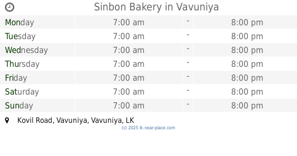
Sinbon Bakery
Kovil Road, Vavuniya
Cafe
read more
44.907 km
Taste & See
No 05, Kovil Road, Thirunavatkulam
Cafe
read more
45.22 km
Soothi Coffe Shop
Nelukkulam, Vavuniya
Cafe
read more
45.584 km
Mahendrarasa
No 19, Barathipuram,, Vavuniya
Cafe
read more
46.172 km
Thiruppathi
Mannar Road, Vavuniya
Cafe
read more
46.253 km
The Yaha pleesing meals
Vairavapuliyankulam, Vavuniya
Cafe
read more
46.368 km
Mech Cafe
Sri Lanka
Cafe
read more
46.819 km
Canteen
Mannar Road, Vavuniya
Cafe
read more
47.436 km
வேல் கபே
A29, Vavuniya
Cafe
read more
47.436 km
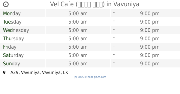
Vel Cafe (வேல் கபே)
A29, Vavuniya
Cafe
read more
47.44 km
Vels
A29, Vavuniya
Cafe
read more
47.449 km
Ambal Cafe
A29, Vavuniya
Cafe
read more
47.459 km
Analas Cool Spot
Vavuniya
Cafe
read more
47.491 km
Suthanatha Vilas
Kandasami Kovil Road, Vavuniya
Cafe
read more
47.527 km
ASK internet cafe
Vavuniya
Cafe
read more
49.308 km
Frozen Creams
Horowpotana Highway, Velikkulam, Vavuniya
Cafe
read more
59.702 km
any resturant on near the sea
Mannar
Cafe
read more
📑
all categories
Accounting
Administrative area level 1
Administrative area level 2
Airport
Amusement park
Aquarium
Art gallery
Atm
Bakery
Bank
Bar
Beauty salon
Bicycle store
Book store
Bowling alley
Bus station
Cafe
Campground
Car dealer
Car rental
Car repair
Car wash
Casino
Cemetery
Church
City hall
Clothing store
Colloquial area
Convenience store
Country
Courthouse
Dentist
Department store
Doctor
Electrician
Electronics store
Embassy
Finance
Fire station
Florist
Food
Funeral home
Furniture store
Gas station
General contractor
Grocery or supermarket
Gym
Hair care
Hardware store
Health
Hindu Temple
Home goods store
Hospital
Insurance agency
Intersection
Jewelry store
Laundry
Lawyer
Library
Light rail station
Liquor store
Local government office
Locality
Locksmith
Lodging
Meal delivery
Meal takeaway
Mosque
Movie rental
Movie theater
Moving company
Museum
Natural feature
Neighborhood
Night club
Painter
Park
Parking
Pet store
Pharmacy
Physiotherapist
Place of worship
Plumber
Point of interest
Police
Political
Post office
Premise
Real estate agency
Restaurant
Roofing contractor
Route
Rv park, camping
School
Shoe store
Shopping mall
Spa
Stadium
Storage
Store
Subpremise
Supermarket
Synagogue
Taxi stand
Train station
Transit station
Travel agency
University
Veterinary care
Zoo
administrative area level 3
sublocality level 1
sublocality level 2
↑