Cafe nearby Nilavan Hotel
Sri Lanka
Cafe nearby Nilavan Hotel
Nilavan Hotel
Pooneryn Sri Lanka
contacts phone
:
+94
Latitude:
9.5044072
, Longitude:
80.2118425
read more
nearest Cafe
6 m
New niron hotel
Pooneryn
Cafe
read more
15.27 km
Rasa Cafe Kachchai
kachchai south kodikamam, kachchai thuraimukam
Cafe
read more
21.431 km
Fresh Fruit Juice, Elephant Pass
Pachchilapalli
Cafe
read more
25.704 km
Kannan Cafe
Jaffna
Cafe
read more
27.179 km
Gowri cafe
Beach Road, Jaffna
Cafe
read more
27.29 km
Aiyngaran hotel
Jaffna
Cafe
read more
27.388 km
SIvanthantha Food store
Jaffna
Cafe
read more
27.642 km
TKS Transport
Navalar Road, Jaffna
Cafe
read more
28.012 km
Hospital Canteen
Hospital Road, Jaffna
Cafe
read more
28.054 km
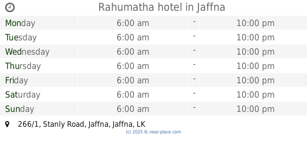
Rahumatha hotel
266/1 Stanly Road, Jaffna
Cafe
read more
28.251 km
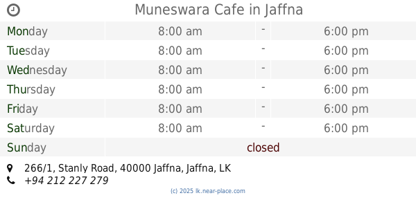
Muneswara Cafe
266/1 Stanly Road, Jaffna
Cafe
read more
28.604 km
Arul Bakery Café
Jaffna
Cafe
read more
28.622 km
Krishna Cafe
B268, Jaffna
Cafe
read more
28.707 km
Royal Bombay Sweets and Snacks
No.212, Kasthuriyar Road,, Jaffna
Cafe
read more
28.734 km
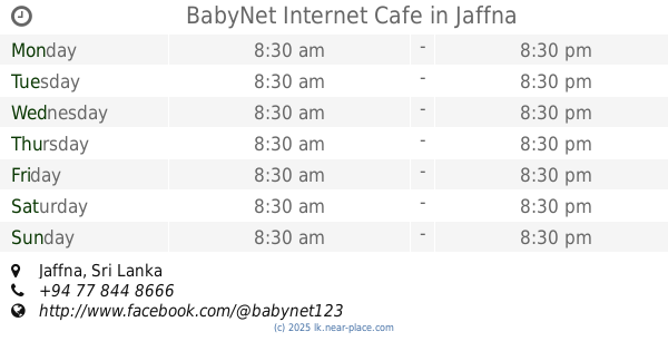
BabyNet Internet Cafe
Jaffna
Cafe
read more
28.788 km
CafeEV Cabs
126, Arasady Road, Kantharmadam, Jaffna
Cafe
read more
28.819 km
Shalini Foods
Jaffna
Cafe
read more
28.826 km
Hit City Hotel
Jaffna
Cafe
read more
28.899 km
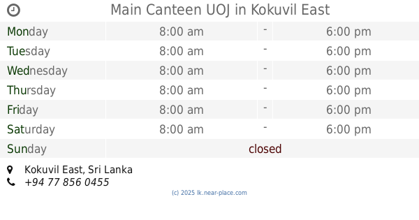
Main Canteen UOJ
Kokuvil East
Cafe
read more
29.598 km
Rajah Ice Cream
Jaffna
Cafe
read more
29.946 km
Star Hotel
Dżafna
Cafe
read more
30.35 km
Yummy Cafe
Jaffna
Cafe
read more
30.53 km
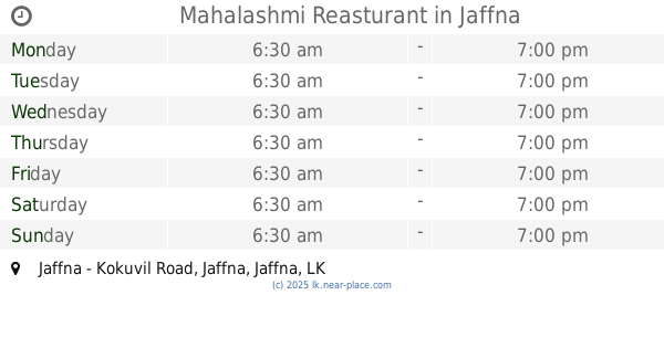
Mahalashmi Reasturant
Jaffna - Kokuvil Road, Jaffna
Cafe
read more
31.494 km
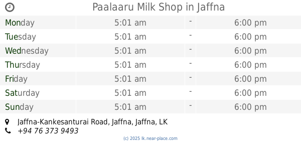
Paalaaru Milk Shop
Jaffna-Kankesanturai Road, Jaffna
Cafe
read more
31.781 km
Star Ice Cream
Manipay Road, Jaffna
Cafe
read more
📑
all categories
Accounting
Administrative area level 1
Administrative area level 2
Airport
Amusement park
Aquarium
Art gallery
Atm
Bakery
Bank
Bar
Beauty salon
Bicycle store
Book store
Bowling alley
Bus station
Cafe
Campground
Car dealer
Car rental
Car repair
Car wash
Casino
Cemetery
Church
City hall
Clothing store
Colloquial area
Convenience store
Country
Courthouse
Dentist
Department store
Doctor
Electrician
Electronics store
Embassy
Finance
Fire station
Florist
Food
Funeral home
Furniture store
Gas station
General contractor
Grocery or supermarket
Gym
Hair care
Hardware store
Health
Hindu Temple
Home goods store
Hospital
Insurance agency
Intersection
Jewelry store
Laundry
Lawyer
Library
Light rail station
Liquor store
Local government office
Locality
Locksmith
Lodging
Meal delivery
Meal takeaway
Mosque
Movie rental
Movie theater
Moving company
Museum
Natural feature
Neighborhood
Night club
Painter
Park
Parking
Pet store
Pharmacy
Physiotherapist
Place of worship
Plumber
Point of interest
Police
Political
Post office
Premise
Real estate agency
Restaurant
Roofing contractor
Route
Rv park, camping
School
Shoe store
Shopping mall
Spa
Stadium
Storage
Store
Subpremise
Supermarket
Synagogue
Taxi stand
Train station
Transit station
Travel agency
University
Veterinary care
Zoo
administrative area level 3
sublocality level 1
sublocality level 2
↑