Cafe nearby Ometh Bakers
Sri Lanka
Cafe nearby Ometh Bakers
Ometh Bakers
Gannoruwa-Muruthalawa Road, Muruthalawa Sri Lanka
contacts phone
:
+94
Latitude:
7.2960905
, Longitude:
80.5794838
read more
nearest Cafe
1.917 km
STAR bake house
Cafe
read more
2.656 km
Amila Enterprises
Sri Lanka
Cafe
read more
2.878 km
M.H.M MOBEIL SHOP
Aladeniya - Murutalawa Road
Cafe
read more
2.903 km
Kavidu Bookshop
Barigama-Halloluwa Road, Halloluwa
Cafe
read more
3.292 km
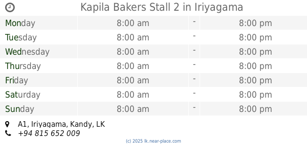
Kapila Bakers Stall 2
A1, Iriyagama
Cafe
read more
3.512 km
M N Traders
Christopher Road
Cafe
read more
3.634 km
Welcome Bake House
Colombo Rd, Peradeniya
Cafe
read more
3.646 km
Barista - Peradeniya
Peradeniya Botanical Gardens, A1, Peradeniya
Cafe
read more
3.686 km
Hela Bojun Food Stalls
Peradeniya
Cafe
read more
4.157 km
Cafe at Crafts
931 Peradeniya Road, Sirimavo Bandaranayake Mawatha, Kandy
Cafe
read more
4.321 km
Sumathi Caters
Katugastota
Cafe
read more
4.378 km
Welfare Shop
Peradeniya
Cafe
read more
4.396 km
Varsity Cheff
University of, University of
Cafe
read more
4.419 km
Royal Garden Mall Coffee Shop
William Gopallawa Mawatha, Kandy
Cafe
read more
4.466 km
Randles Cafe
Peradeniya Road, Kandy
Cafe
read more
4.577 km
Geragama Tea Centre
Sri Lanka
Cafe
read more
4.714 km
Rms bombay sweets
Kandy
Cafe
read more
4.757 km
Net Zone
Kandy
Cafe
read more
4.911 km
'Isira Cool Spot By Bibile'
Gadaldeniya Road
Cafe
read more
5.037 km
Delight
George E De Silva Mawatha, Kandy
Cafe
read more
5.132 km
Feelhome
Heerassagala Road, Kandy
Cafe
read more
5.168 km
P & S Bakers
91 Ranawana Road, Kanday
Cafe
read more
5.418 km
Chinatown Cafe
Richmond Hill Lane
Cafe
read more
5.729 km
E-Town Computers & Internet Cafe
Katugastota-Kurunegala-Puttalam Highway, Katugastota
Cafe
read more
6.044 km
Makuldeniya Hotel
Madawala Road, Katugastota
Cafe
read more
📑
all categories
Accounting
Administrative area level 1
Administrative area level 2
Airport
Amusement park
Aquarium
Art gallery
Atm
Bakery
Bank
Bar
Beauty salon
Bicycle store
Book store
Bowling alley
Bus station
Cafe
Campground
Car dealer
Car rental
Car repair
Car wash
Casino
Cemetery
Church
City hall
Clothing store
Colloquial area
Convenience store
Country
Courthouse
Dentist
Department store
Doctor
Electrician
Electronics store
Embassy
Finance
Fire station
Florist
Food
Funeral home
Furniture store
Gas station
General contractor
Grocery or supermarket
Gym
Hair care
Hardware store
Health
Hindu Temple
Home goods store
Hospital
Insurance agency
Intersection
Jewelry store
Laundry
Lawyer
Library
Light rail station
Liquor store
Local government office
Locality
Locksmith
Lodging
Meal delivery
Meal takeaway
Mosque
Movie rental
Movie theater
Moving company
Museum
Natural feature
Neighborhood
Night club
Painter
Park
Parking
Pet store
Pharmacy
Physiotherapist
Place of worship
Plumber
Point of interest
Police
Political
Post office
Premise
Real estate agency
Restaurant
Roofing contractor
Route
Rv park, camping
School
Shoe store
Shopping mall
Spa
Stadium
Storage
Store
Subpremise
Supermarket
Synagogue
Taxi stand
Train station
Transit station
Travel agency
University
Veterinary care
Zoo
administrative area level 3
sublocality level 1
sublocality level 2
↑