Cafe nearby Ranfer Tea Shop
Sri Lanka
Cafe nearby Ranfer Tea Shop
Ranfer Tea Shop
16 Flower Rd, Colombo 00700, Sri Lanka
contacts phone
:
+94 112 372 012
website:
www.ranfertea.com
Latitude:
6.910968
, Longitude:
79.856359
larger map & directions
read more
nearest Cafe
10 m
The Cozy Lounge
16 Flower Road, Colombo
Cafe
read more
15 m
Choco Luv
16 Flower Road, Colombo
Cafe
read more
114 m
CAFE NUGA
69A Ananda Coomaraswamy Mawatha
Cafe
read more
497 m
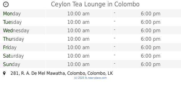
Ceylon Tea Lounge
281 R. A. De Mel Mawatha, Colombo
Cafe
read more
500 m
Townhouse
Liberty Arcade, 282, R. A. De Mel Mawatha, Colombo
Cafe
read more
526 m
Rancrisp Cashew
145 Srimath Anagarika Dharmapala Mawatha, Colombo
Cafe
read more
564 m
The Coffee Bean & Tea Leaf
1st Floor, Liberty Plaza, Colombo
Cafe
read more
566 m
Macchiato
Libery Plaza, R. A. De Mel Mawatha, Colombo
Cafe
read more
612 m
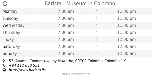
Barista - Museum
53 Ananda Coomaraswamy Mawatha, Colombo
Cafe
read more
680 m
Life Food
31 Perahera Mawatha, Colombo
Cafe
read more
712 m
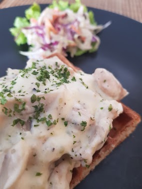
The Waffle Cafe
A - 14 Perehara Mawatha, Colombo 00200
Cafe
read more
720 m
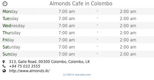
Almonds Cafe
313 Galle Road, Colombo
Cafe
read more
734 m
Cafe Cabin
Deal Place, Colombo
Cafe
read more
754 m
Coffee & Company
37/3, පෙඩ්රිස් පාර, කොළඹ
Cafe
read more
770 m
BreadTalk
33 Park Street, Colombo
Cafe
read more
773 m
Sun Rise Cafe
Colombo
Cafe
read more
776 m
Royal College Milk Bar
Colombo
Cafe
read more
847 m
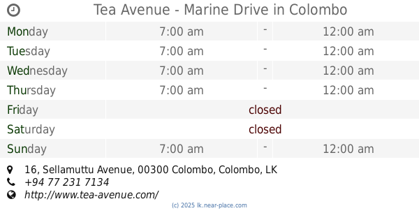
Tea Avenue - Marine Drive
16 Sellamuttu Avenue, Colombo
Cafe
read more
892 m
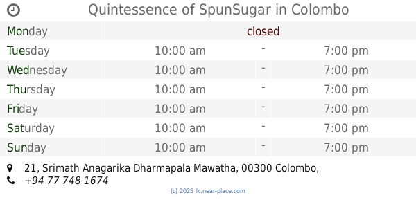
Quintessence of SpunSugar
21 Srimath Anagarika Dharmapala Mawatha, Colombo
Cafe
read more
985 m
Mitsis
Bagatalle Road, Colombo
Cafe
read more
1.037 km
Kirā Headquaters
Colombo
Cafe
read more
1.053 km
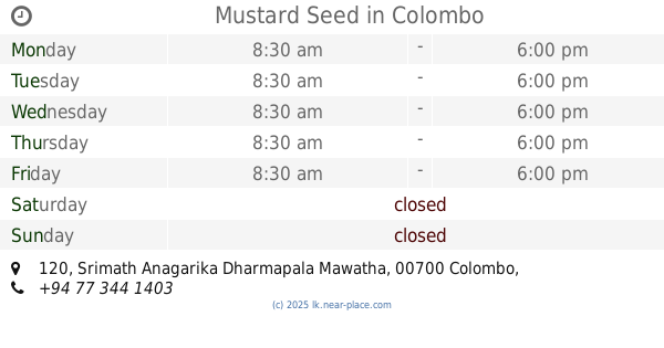
Mustard Seed
120 Srimath Anagarika Dharmapala Mawatha, Colombo
Cafe
read more
1.119 km
Techno Cafe
475 Union Place, Colombo
Cafe
read more
1.161 km
Raxawa Tea Lounge
532/3J Marine Drive, Colombo
Cafe
read more
1.168 km
Araliya Tea Service
46/42, 02,, Colombo
Cafe
read more
📑
all categories
Accounting
Administrative area level 1
Administrative area level 2
Airport
Amusement park
Aquarium
Art gallery
Atm
Bakery
Bank
Bar
Beauty salon
Bicycle store
Book store
Bowling alley
Bus station
Cafe
Campground
Car dealer
Car rental
Car repair
Car wash
Casino
Cemetery
Church
City hall
Clothing store
Colloquial area
Convenience store
Country
Courthouse
Dentist
Department store
Doctor
Electrician
Electronics store
Embassy
Finance
Fire station
Florist
Food
Funeral home
Furniture store
Gas station
General contractor
Grocery or supermarket
Gym
Hair care
Hardware store
Health
Hindu Temple
Home goods store
Hospital
Insurance agency
Intersection
Jewelry store
Laundry
Lawyer
Library
Light rail station
Liquor store
Local government office
Locality
Locksmith
Lodging
Meal delivery
Meal takeaway
Mosque
Movie rental
Movie theater
Moving company
Museum
Natural feature
Neighborhood
Night club
Painter
Park
Parking
Pet store
Pharmacy
Physiotherapist
Place of worship
Plumber
Point of interest
Police
Political
Post office
Premise
Real estate agency
Restaurant
Roofing contractor
Route
Rv park, camping
School
Shoe store
Shopping mall
Spa
Stadium
Storage
Store
Subpremise
Supermarket
Synagogue
Taxi stand
Train station
Transit station
Travel agency
University
Veterinary care
Zoo
administrative area level 3
sublocality level 1
sublocality level 2
↑