Church nearby St. Sylvester Church
Sri Lanka
Church nearby St. Sylvester Church
St. Sylvester Church
Negombo, Sri Lanka
contacts phone
:
+94
Latitude:
7.2362123
, Longitude:
79.8445549
larger map & directions
read more
nearest Church
39 m
St. Sylvester's Church
Ettukala Road, Ettukala, Negombo
Church
read more
117 m
St. Anthony's Shrine
Negombo
Church
read more
803 m
Holy Rosary Church
Kudapaduwa, Negombo
Church
read more
1.299 km
St. Anthony's Shrine
Thimbirigaskatuwa Road, Negombo
Church
read more
1.322 km
Our Lady of Snows Church
Negombo
Church
read more
1.412 km
Methodist Church
Negombo
Church
read more
1.487 km
Velankanni Arogya Matha Church
Negombo
Church
read more
1.49 km
St. Anne's Church
நீர்கொழும்பு
Church
read more
1.494 km
St. Anne Church, Palagathurei
111 Saint Anns Road, Negombo
Church
read more
1.579 km
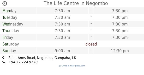
The Life Centre
531/14 A, Saint Anns Road, Negombo
Church
read more
2.055 km
St. Sebastian's Church
Sea Street, Negombo
Church
read more
2.095 km
Holy Cross Church
mahimagodallawatha, Negombo
Church
read more
2.196 km
Sellakanda Catholic Cemetery
Sellakanda, Negombo
Church
read more
2.279 km
The Church of Jesus Christ of Latter-day Saints
Chilaw Road, Negombo
Church
read more
2.285 km
St. Sebastian church
Negombo
Church
read more
2.376 km
Good sheperd God Mission
163/6 Sea Street, Negombo
Church
read more
2.501 km
Seventh Day Adventist Church
347/2a Main Street, Negombo
Church
read more
2.632 km
Welihena Church
Negombo
Church
read more
2.651 km
St. Nicholas Church (Nellumpitiya)
B322, Negombo
Church
read more
2.969 km
Our Lady Of Sorrows Statue
Dolorosa Road, Negombo
Church
read more
3.195 km
Methodist Church
Customs House Road, Negombo
Church
read more
3.232 km
St. Sebastian's Church
Katuwapitiya Road, Negombo
Church
read more
3.232 km
St. Sebastian's Church, Katuwapitiya
Katuwapitiya Road, Negombo
Church
read more
4.048 km
Toppuwa RC Church
Sri Lanka
Church
read more
4.058 km
St. Philip Neri's Church
Kochchikade - Halpe Road
Church
read more
📑
all categories
Accounting
Administrative area level 1
Administrative area level 2
Airport
Amusement park
Aquarium
Art gallery
Atm
Bakery
Bank
Bar
Beauty salon
Bicycle store
Book store
Bowling alley
Bus station
Cafe
Campground
Car dealer
Car rental
Car repair
Car wash
Casino
Cemetery
Church
City hall
Clothing store
Colloquial area
Convenience store
Country
Courthouse
Dentist
Department store
Doctor
Electrician
Electronics store
Embassy
Finance
Fire station
Florist
Food
Funeral home
Furniture store
Gas station
General contractor
Grocery or supermarket
Gym
Hair care
Hardware store
Health
Hindu Temple
Home goods store
Hospital
Insurance agency
Intersection
Jewelry store
Laundry
Lawyer
Library
Light rail station
Liquor store
Local government office
Locality
Locksmith
Lodging
Meal delivery
Meal takeaway
Mosque
Movie rental
Movie theater
Moving company
Museum
Natural feature
Neighborhood
Night club
Painter
Park
Parking
Pet store
Pharmacy
Physiotherapist
Place of worship
Plumber
Point of interest
Police
Political
Post office
Premise
Real estate agency
Restaurant
Roofing contractor
Route
Rv park, camping
School
Shoe store
Shopping mall
Spa
Stadium
Storage
Store
Subpremise
Supermarket
Synagogue
Taxi stand
Train station
Transit station
Travel agency
University
Veterinary care
Zoo
administrative area level 3
sublocality level 1
sublocality level 2
↑