Gas station nearby Makandura JAI Gas Station
Sri Lanka
Gas station nearby Makandura JAI Gas Station
Makandura JAI Gas Station
Negombo-Kurunegala Road, Kurunegala, North Western Province, LK Sri Lanka
contacts phone
:
+94
Latitude:
7.3254385
, Longitude:
79.9875025
larger map & directions
read more
nearest Gas station
2.279 km
Sandalankawa Lanka IOC Petrol Shed
Negombo-Kurunegala Road
Gas station
read more
3.43 km
IOC Gas Station.
Pannala
Gas station
read more
3.849 km
Ceypetco
Pannala Police Station Road, Pannala
Gas station
read more
3.852 km
Pannala Gas Station
Pannala
Gas station
read more
4.351 km
Lanka Filling Station
Pannala
Gas station
read more
4.38 km
Lanka Indian Oil Company
Badalgama
Gas station
read more
9.822 km
Jayakodi Fuel Station
B111
Gas station
read more
10.559 km
CeyPetCo Fuel Station Dunagaha
Dunagaha
Gas station
read more
10.874 km
Kularathne Fuel Station
Marandagahamula
Gas station
read more
11.747 km
KARUNARATHNE FUEL MART
Dankotuwa
Gas station
read more
12.232 km
Nawa Lanka Sewa Filing Station
Janadhipathi Mawatha, Colombo
Gas station
read more
13.486 km
CEYPETCO Samansiri Enterprises
Kurunegala
Gas station
read more
13.513 km
Chathuranga Wijesuriya
Katana
Gas station
read more
13.963 km
Lanka IOC
Negombo - Giriulla Road
Gas station
read more
14.892 km
Fuel Station
AB29, Giriulla
Gas station
read more
15.402 km
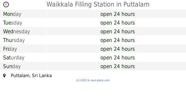
Waikkala Filling Station
Puttalam
Gas station
read more
15.696 km
Filling Station
1, 316/1/1 හලාවත - කොළඹ ප්රධාන පාර
Gas station
read more
15.7 km
Joe & Sons
Negombo
Gas station
read more
15.98 km
Elight Gas Station - IOC
நீர்கொழும்பு
Gas station
read more
15.98 km
Elight Gas Station - IOC
Negombo
Gas station
read more
16.063 km
Ceypetco Filling Station
Toppuwa-Nattandiya-Madampe Road
Gas station
read more
18.297 km
Ramanayaka Filling Station Pallewela
Kaleliya - Medagampitiya Road, Pallewela
Gas station
read more
19.081 km
Litro Gas
Jayarathna Road, Negombo
Gas station
read more
20.097 km
Laugfs Filling Station
Negombo
Gas station
read more
20.382 km
Ceypetco Fuel Station
Negombo
Gas station
read more
📑
all categories
Accounting
Administrative area level 1
Administrative area level 2
Airport
Amusement park
Aquarium
Art gallery
Atm
Bakery
Bank
Bar
Beauty salon
Bicycle store
Book store
Bowling alley
Bus station
Cafe
Campground
Car dealer
Car rental
Car repair
Car wash
Casino
Cemetery
Church
City hall
Clothing store
Colloquial area
Convenience store
Country
Courthouse
Dentist
Department store
Doctor
Electrician
Electronics store
Embassy
Finance
Fire station
Florist
Food
Funeral home
Furniture store
Gas station
General contractor
Grocery or supermarket
Gym
Hair care
Hardware store
Health
Hindu Temple
Home goods store
Hospital
Insurance agency
Intersection
Jewelry store
Laundry
Lawyer
Library
Light rail station
Liquor store
Local government office
Locality
Locksmith
Lodging
Meal delivery
Meal takeaway
Mosque
Movie rental
Movie theater
Moving company
Museum
Natural feature
Neighborhood
Night club
Painter
Park
Parking
Pet store
Pharmacy
Physiotherapist
Place of worship
Plumber
Point of interest
Police
Political
Post office
Premise
Real estate agency
Restaurant
Roofing contractor
Route
Rv park, camping
School
Shoe store
Shopping mall
Spa
Stadium
Storage
Store
Subpremise
Supermarket
Synagogue
Taxi stand
Train station
Transit station
Travel agency
University
Veterinary care
Zoo
administrative area level 3
sublocality level 1
sublocality level 2
↑