Lodging nearby Tranquil Villa
Sri Lanka
Lodging nearby Tranquil Villa
Tranquil Villa
Kaduwela, Sri Lanka
contacts phone
:
+94 112 548 819
website:
www.tranquilvilla.lk
Latitude:
6.9369235
, Longitude:
79.9712835
larger map & directions
read more
nearest Lodging
387 m
Wijitha Hotel
Raggahawatta
Lodging
read more
496 m
The Shady Family Hotel
Raggahawatta
Lodging
read more
500 m
Hotel River Park
Mabima West
Lodging
read more
623 m
Navindu Hotel
Rajasinghe Mawatha, Kaduwela
Lodging
read more
655 m
Sudeepa Hotel
Hewagama, Kaduwela
Lodging
read more
672 m
Moreliya Chinese Foods
Sri Lanka
Lodging
read more
688 m
The River Edge
157 Kaduwela Road, Kaduwela
Lodging
read more
757 m
Hotel Little Hut
Sri Lanka
Lodging
read more
757 m
Hotel Little Hut
513 AB10, Kaduwela
Lodging
read more
916 m
Nilnadee Inn
Sri Lanka
Lodging
read more
966 m
Hotel Teak Garden
No: 506E, Colombo Road., Kaduwela
Lodging
read more
1.051 km
The Serene Court Housing Scheme
The Serene Court Housing Scheme, Kaduwela
Lodging
read more
1.133 km
Serene Hostels
No.225 / 84 Vihara Lane, Kaduwela
Lodging
read more
1.364 km
Pigera Stores
Welivita Road, Welivita
Lodging
read more
1.461 km
Crossroads Villa
142/7, Colombo Road
Lodging
read more
1.51 km
Woodland Cottage
170, Welivita , Kaduwela, Weliwita
Lodging
read more
1.53 km
Grand Anupama Hotel
Welivita
Lodging
read more
1.661 km
Horizon Hostel
Welivita Road, Welivita
Lodging
read more
1.669 km
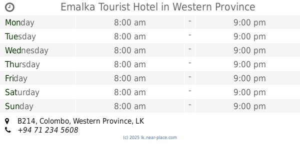
Emalka Tourist Hotel
B214
Lodging
read more
1.691 km
Proposed Boys Hostel for Horizon Campus
Sri Lanka
Lodging
read more
1.706 km
Gurugedara Girls Hostel
Vihara Lane, Kaduwela
Lodging
read more
1.721 km
La Rose Hotel
No: 155/1 F, New Kandy Road,, Bandarawatta,, Kaduwela
Lodging
read more
1.734 km
River frount
133 Kaduwela Road, Kaduwela
Lodging
read more
1.814 km
Flower Garden Hotel
Welivita
Lodging
read more
1.946 km
Mada Midula Hotel
Pahala Bomiriya
Lodging
read more
📑
all categories
Accounting
Administrative area level 1
Administrative area level 2
Airport
Amusement park
Aquarium
Art gallery
Atm
Bakery
Bank
Bar
Beauty salon
Bicycle store
Book store
Bowling alley
Bus station
Cafe
Campground
Car dealer
Car rental
Car repair
Car wash
Casino
Cemetery
Church
City hall
Clothing store
Colloquial area
Convenience store
Country
Courthouse
Dentist
Department store
Doctor
Electrician
Electronics store
Embassy
Finance
Fire station
Florist
Food
Funeral home
Furniture store
Gas station
General contractor
Grocery or supermarket
Gym
Hair care
Hardware store
Health
Hindu Temple
Home goods store
Hospital
Insurance agency
Intersection
Jewelry store
Laundry
Lawyer
Library
Light rail station
Liquor store
Local government office
Locality
Locksmith
Lodging
Meal delivery
Meal takeaway
Mosque
Movie rental
Movie theater
Moving company
Museum
Natural feature
Neighborhood
Night club
Painter
Park
Parking
Pet store
Pharmacy
Physiotherapist
Place of worship
Plumber
Point of interest
Police
Political
Post office
Premise
Real estate agency
Restaurant
Roofing contractor
Route
Rv park, camping
School
Shoe store
Shopping mall
Spa
Stadium
Storage
Store
Subpremise
Supermarket
Synagogue
Taxi stand
Train station
Transit station
Travel agency
University
Veterinary care
Zoo
administrative area level 3
sublocality level 1
sublocality level 2
↑