Park nearby Mirihana Police Grounds
Sri Lanka
Park nearby Mirihana Police Grounds
Mirihana Police Grounds
Nugegoda, Sri Lanka
contacts phone
:
+94
Latitude:
6.8730937
, Longitude:
79.8997663
larger map & directions
read more
nearest Park
630 m
Robert Gunawardane Children's Park
Mirihana
Park
read more
1.005 km
Agrozone
196/E, Avissawella Road, Nugegoda
Park
read more
1.101 km
Urban Wetland Park
Nugegoda West
Park
read more
1.104 km
Urban Wetland Park (Nugegoda)
Ethul Kotte
Park
read more
1.133 km
Weli Park
Nawala Road, Sri Jayawardenepura Kotte
Park
read more
1.135 km
Nawala walking track
B307, Sri Jayawardenepura Kotte
Park
read more
1.19 km
Diyawanna Childrens' Park
Nugegoda
Park
read more
1.714 km
Baddagana Children's Park
Sri Jayawardenepura Kotte
Park
read more
1.722 km
Sandru
Kirulapone, Colombo
Park
read more
1.754 km
Baddegana Public Cemetry බැද්දගාන පොදු සුසාන භූමිය
Sri Jayawardenepura Kotte
Park
read more
1.822 km
Queen's Park Residencies
Sri Lanka
Park
read more
1.848 km
Children's Park
East
Park
read more
2.29 km
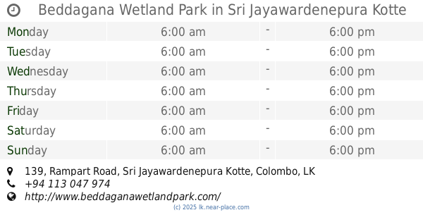
Beddagana Wetland Park
139 Rampart Road, Sri Jayawardenepura Kotte
Park
read more
2.518 km
The Wet Water Park
Nawala Road, Sri Jayawardenepura Kotte
Park
read more
2.805 km
Jayasankhapura Children's Park
Kalubowila
Park
read more
2.929 km
National Ranaviru Monument
Battaramulla
Park
read more
3.047 km
Parliament Grounds
Parliament Drive, Sri Jayawardenepura Kotte
Park
read more
3.191 km
Dissanayaka Niwasa
49, Nikape Road, දෙහිවල-ගල්කිස්ස
Park
read more
3.191 km
Dissanayaka Niwasa
49, B94, දෙහිවල-ගල්කිස්ස
Park
read more
3.223 km
Statue of War Indian War Heros
Statue of War Indian War Heros, Parliament Road, Sri Jayawardenepura Kotte
Park
read more
3.278 km
Herbal Garden
Battaramulla
Park
read more
3.408 km
Mahawatte Playground
Dabare Lane, Colombo
Park
read more
3.428 km
Subhodha Enterprices
No 1127/2 Mihindupura,, Battaramulla
Park
read more
3.539 km
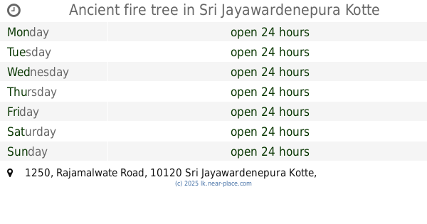
Ancient fire tree
1250 Rajamalwate Road, Sri Jayawardenepura Kotte
Park
read more
3.687 km
Sandun Gardens
Maharagama
Park
read more
📑
all categories
Accounting
Administrative area level 1
Administrative area level 2
Airport
Amusement park
Aquarium
Art gallery
Atm
Bakery
Bank
Bar
Beauty salon
Bicycle store
Book store
Bowling alley
Bus station
Cafe
Campground
Car dealer
Car rental
Car repair
Car wash
Casino
Cemetery
Church
City hall
Clothing store
Colloquial area
Convenience store
Country
Courthouse
Dentist
Department store
Doctor
Electrician
Electronics store
Embassy
Finance
Fire station
Florist
Food
Funeral home
Furniture store
Gas station
General contractor
Grocery or supermarket
Gym
Hair care
Hardware store
Health
Hindu Temple
Home goods store
Hospital
Insurance agency
Intersection
Jewelry store
Laundry
Lawyer
Library
Light rail station
Liquor store
Local government office
Locality
Locksmith
Lodging
Meal delivery
Meal takeaway
Mosque
Movie rental
Movie theater
Moving company
Museum
Natural feature
Neighborhood
Night club
Painter
Park
Parking
Pet store
Pharmacy
Physiotherapist
Place of worship
Plumber
Point of interest
Police
Political
Post office
Premise
Real estate agency
Restaurant
Roofing contractor
Route
Rv park, camping
School
Shoe store
Shopping mall
Spa
Stadium
Storage
Store
Subpremise
Supermarket
Synagogue
Taxi stand
Train station
Transit station
Travel agency
University
Veterinary care
Zoo
administrative area level 3
sublocality level 1
sublocality level 2
↑