School nearby Deealla Revatha college
Sri Lanka
School nearby Deealla Revatha college
Deealla Revatha college
Deegalla Elathalawa Road Sri Lanka
contacts phone
:
+94
Latitude:
7.5116836
, Longitude:
80.0386941
read more
nearest School
22 m
Rewatha Maha Vidyalaya
Deegalla
School
read more
2.258 km
Pubudu Montessori
E/Elathalawa Deegalla
School
read more
2.458 km
Paragaharuppa School
Kurunegala
School
read more
2.722 km
Galpola school
Kurunegala
School
read more
2.869 km
Abawa school
Mahasen Mawatha
School
read more
2.887 km
Bogoda Pablic school
Bogoda,Deegalla.
School
read more
2.889 km
Saranankara Vidyalaya
Sri Lanka
School
read more
2.955 km
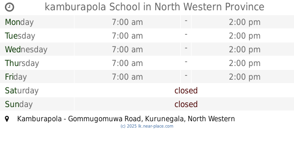
kamburapola School
Kamburapola - Gommugomuwa Road
School
read more
3.159 km
Elathalawa School
Elathalawa Road
School
read more
3.536 km
Gommugomuwa Pablic School.
Gommugomuwa Road,
School
read more
3.622 km
Kuli/Ilukhena Gunanada M.V
Kuliyapitiya-Padiwela Road, Ilukhena
School
read more
3.637 km
Ilukhena Gunananda Maha Vidyalaya
Ilukhena
School
read more
4.098 km
Sri Sumangala Primary School, Wassaulla
Kurunegala
School
read more
4.098 km
Subarathi Primary School, Wassaulla
Kurunegala
School
read more
4.142 km
Subharathi Junior School
Sri Lanka
School
read more
4.219 km
Visaka Balika Vidyalaya
Kuliyapitiya
School
read more
4.437 km
Sarasavi English School
Mihindu Mawatha, Kuliyapitiya
School
read more
4.706 km
ST.Joseph's College .
Kuliyapitiya
School
read more
4.728 km
Holy Angels Girls' College
Kurunegala-Narammala-Madampe Road, Kuliyapitiya
School
read more
4.77 km
Kuliyapitiya English Camp
Kurunegala-Narammala-Madampe Rd, Kuliyapitiya
School
read more
4.808 km
LTC Kuliyapitiya
Kuliyapitiya
School
read more
4.866 km
Kanadulla Dharmaraja Adarsha Maha Vidyalaya
Dandagamuwa
School
read more
4.926 km
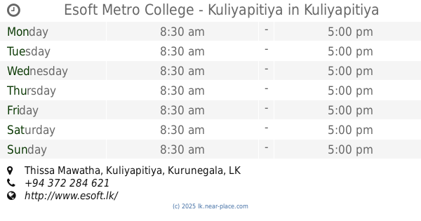
Esoft Metro College - Kuliyapitiya
Thissa Mawatha, Kuliyapitiya
School
read more
5.014 km
Assedduma Subharathi Vidyalaya
Kuliyapitiya
School
read more
5.055 km
Nursery
Madiye Vidiyawala Road
School
read more
📑
all categories
Accounting
Administrative area level 1
Administrative area level 2
Airport
Amusement park
Aquarium
Art gallery
Atm
Bakery
Bank
Bar
Beauty salon
Bicycle store
Book store
Bowling alley
Bus station
Cafe
Campground
Car dealer
Car rental
Car repair
Car wash
Casino
Cemetery
Church
City hall
Clothing store
Colloquial area
Convenience store
Country
Courthouse
Dentist
Department store
Doctor
Electrician
Electronics store
Embassy
Finance
Fire station
Florist
Food
Funeral home
Furniture store
Gas station
General contractor
Grocery or supermarket
Gym
Hair care
Hardware store
Health
Hindu Temple
Home goods store
Hospital
Insurance agency
Intersection
Jewelry store
Laundry
Lawyer
Library
Light rail station
Liquor store
Local government office
Locality
Locksmith
Lodging
Meal delivery
Meal takeaway
Mosque
Movie rental
Movie theater
Moving company
Museum
Natural feature
Neighborhood
Night club
Painter
Park
Parking
Pet store
Pharmacy
Physiotherapist
Place of worship
Plumber
Point of interest
Police
Political
Post office
Premise
Real estate agency
Restaurant
Roofing contractor
Route
Rv park, camping
School
Shoe store
Shopping mall
Spa
Stadium
Storage
Store
Subpremise
Supermarket
Synagogue
Taxi stand
Train station
Transit station
Travel agency
University
Veterinary care
Zoo
administrative area level 3
sublocality level 1
sublocality level 2
↑