School nearby MR/Jamburegoda Maha Vidyalaya
Sri Lanka
School nearby MR/Jamburegoda Maha Vidyalaya
MR/Jamburegoda Maha Vidyalaya
Weligama - Imaduwa Road, Matara, Southern Province, LK Sri Lanka
contacts phone
:
+94
Latitude:
6.0073413
, Longitude:
80.4151743
larger map & directions
read more
nearest School
1.522 km
matara.ibbawala kanitu viduhala
Matara
School
read more
1.559 km
Udaya Pre-School
Udaya pre-school,Weligama Imaduwa Rd,Imaduwa
School
read more
1.707 km
Horadugoda Primary College
Sri Lanka
School
read more
1.71 km
Horadugoda Primary College
Matara
School
read more
2.25 km
Hemachandra Gunasekara Maha Vidyalaya
Weligama
School
read more
2.314 km
PALALLA VIDYALAYA
Palalla Road, Weligama
School
read more
2.342 km
Jayasooriya National School, Palalla
Weligama
School
read more
2.415 km
Kokmaduwa Primary School
Kokmaduwa Kananke Weligama Road
School
read more
2.598 km
Andugoda Kanitu Viduhala
Andugoda, Andugoda Pu
School
read more
2.788 km
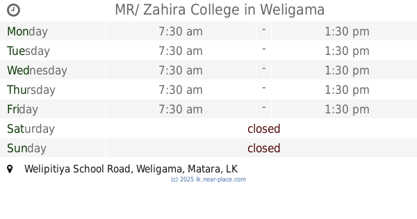
MR/ Zahira College
Welipitiya School Road, Weligama
School
read more
3.027 km
Batawala Pathegama Primary School
Welegoda Road, Pathegama
School
read more
3.191 km
school canteen
Weligama
School
read more
3.208 km
Imaduwa VTC
Diwelagoda,Imaduwa
School
read more
3.274 km
ARAFA NATIONAL SCHOOL
Jinna Road, Weligama
School
read more
3.274 km
Arafa National College
Weligama
School
read more
3.275 km
school main hall
Weligama
School
read more
3.279 km
Arfa Central College
Weligama
School
read more
3.302 km
Kodagoda Upathissa Primary College
Sri Lanka
School
read more
3.303 km
Kodagoda Upathissa Primary College
Galle
School
read more
3.306 km
Staff Room
Weligama
School
read more
3.358 km
Watagedaramulla vidhyalaya
Weligama
School
read more
3.43 km
Jennath Internationl School
No 303, Weligama - Kananke Road, Weligama
School
read more
3.508 km
New Dhawrathu Hadees
Weligama
School
read more
3.55 km
Hilriya Madrasa
Weligama
School
read more
3.816 km
Shine Star Pre-School
Weligama
School
read more
📑
all categories
Accounting
Administrative area level 1
Administrative area level 2
Airport
Amusement park
Aquarium
Art gallery
Atm
Bakery
Bank
Bar
Beauty salon
Bicycle store
Book store
Bowling alley
Bus station
Cafe
Campground
Car dealer
Car rental
Car repair
Car wash
Casino
Cemetery
Church
City hall
Clothing store
Colloquial area
Convenience store
Country
Courthouse
Dentist
Department store
Doctor
Electrician
Electronics store
Embassy
Finance
Fire station
Florist
Food
Funeral home
Furniture store
Gas station
General contractor
Grocery or supermarket
Gym
Hair care
Hardware store
Health
Hindu Temple
Home goods store
Hospital
Insurance agency
Intersection
Jewelry store
Laundry
Lawyer
Library
Light rail station
Liquor store
Local government office
Locality
Locksmith
Lodging
Meal delivery
Meal takeaway
Mosque
Movie rental
Movie theater
Moving company
Museum
Natural feature
Neighborhood
Night club
Painter
Park
Parking
Pet store
Pharmacy
Physiotherapist
Place of worship
Plumber
Point of interest
Police
Political
Post office
Premise
Real estate agency
Restaurant
Roofing contractor
Route
Rv park, camping
School
Shoe store
Shopping mall
Spa
Stadium
Storage
Store
Subpremise
Supermarket
Synagogue
Taxi stand
Train station
Transit station
Travel agency
University
Veterinary care
Zoo
administrative area level 3
sublocality level 1
sublocality level 2
↑