School nearby uniQue Preschool
Sri Lanka
School nearby uniQue Preschool
uniQue Preschool
405/E/, 01st Milepost, Maeliya, Ja-Ela, Sri Lanka
contacts phone
:
+94 112 229 395
Latitude:
7.0756115
, Longitude:
79.99263
larger map & directions
read more
nearest School
298 m
Tikiri Pre School
Gampaha
School
read more
586 m
Best Days AMI Montessori
Oruthota South, Gampaha
School
read more
884 m
Moragoda Wimaladaramasooriya MV
Gampaha
School
read more
1.003 km
Gajaba School
Church Road, Gampaha
School
read more
1.05 km
Scout Den
62/1 Vishaka Road, Gampaha
School
read more
1.055 km
Lumbini Kanishta Vidyalaya
Gampaha
School
read more
1.172 km
Vishakha International Pre School
Vishaka Road, Gampaha
School
read more
1.263 km
Weerasinghe Nursery School
71, Vijaya, Rd, Gampaha, Gampaha
School
read more
1.684 km
Sunanda Nenasala ICT Center
Sri Sunandarama Piriven Maha viharaya, Gampaha
School
read more
1.724 km
Gampaha Sunanada Nenasala
Medagama Kanda Raja Maha Viharaya, Gampaha
School
read more
1.813 km
IDM Achievers International Campus (Gampaha)
5A/1, Sri Wijasri Mw, Ranathunga Rd., Gampaha
School
read more
1.847 km
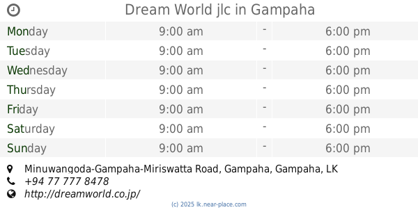
Dream World jlc
1, Minuwangoda-Gampaha-Miriswatta Road, Gampaha
School
read more
1.888 km
Mahena Ground
Mahena
School
read more
1.921 km
Inspiro
Gampaha
School
read more
1.934 km
Sri Gunarathana Dahampasala
Pahalayagoda, Ganemulla
School
read more
1.935 km
Angile vision
Tissa Road, Gampaha
School
read more
1.986 km
Smi Vocational Training Institute
2/a,, 237 Colombo Road, ගම්පහ
School
read more
2.027 km
Swarnapali Balika Vidyalaya
Weera Mawatha, Gampaha
School
read more
2.131 km
Yashodha Dancing Academy
Yakkala Road, Gampaha
School
read more
2.245 km
Holy Cross College Gampaha
Gampaha
School
read more
2.34 km
Bandaranayake College
Kalyani Road, Gampaha
School
read more
2.368 km
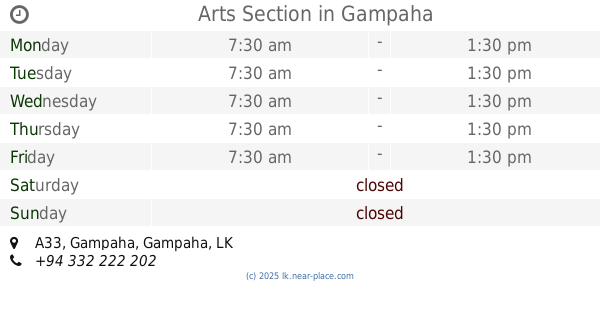
Arts Section
A33, Gampaha
School
read more
2.405 km
Bandaranayake Hall
Gampaha
School
read more
2.456 km
Sri Bhodhiraja Kanishta Vidyalaya
Gampaha
School
read more
2.464 km
JMC Gampaha
136 Yakkala Road, Gampaha
School
read more
📑
all categories
Accounting
Administrative area level 1
Administrative area level 2
Airport
Amusement park
Aquarium
Art gallery
Atm
Bakery
Bank
Bar
Beauty salon
Bicycle store
Book store
Bowling alley
Bus station
Cafe
Campground
Car dealer
Car rental
Car repair
Car wash
Casino
Cemetery
Church
City hall
Clothing store
Colloquial area
Convenience store
Country
Courthouse
Dentist
Department store
Doctor
Electrician
Electronics store
Embassy
Finance
Fire station
Florist
Food
Funeral home
Furniture store
Gas station
General contractor
Grocery or supermarket
Gym
Hair care
Hardware store
Health
Hindu Temple
Home goods store
Hospital
Insurance agency
Intersection
Jewelry store
Laundry
Lawyer
Library
Light rail station
Liquor store
Local government office
Locality
Locksmith
Lodging
Meal delivery
Meal takeaway
Mosque
Movie rental
Movie theater
Moving company
Museum
Natural feature
Neighborhood
Night club
Painter
Park
Parking
Pet store
Pharmacy
Physiotherapist
Place of worship
Plumber
Point of interest
Police
Political
Post office
Premise
Real estate agency
Restaurant
Roofing contractor
Route
Rv park, camping
School
Shoe store
Shopping mall
Spa
Stadium
Storage
Store
Subpremise
Supermarket
Synagogue
Taxi stand
Train station
Transit station
Travel agency
University
Veterinary care
Zoo
administrative area level 3
sublocality level 1
sublocality level 2
↑