Supermarket nearby TS Super
Sri Lanka
Supermarket nearby TS Super
TS Super
Dippitiya, Sri Lanka
contacts phone
:
+94 77 342 0774
Latitude:
7.1753572
, Longitude:
80.4581698
larger map & directions
read more
nearest Supermarket
120 m
Junaid Super
Dippitiya
Supermarket
read more
1.495 km
Jayathissa Trade center
Mawanella-Aranayake-Horawela Road, Aranayake
Supermarket
read more
4.688 km
Sathosa
Hemmathagama
Supermarket
read more
4.763 km
Grosser's Shop
Ginihappitiya
Supermarket
read more
4.934 km
RASDEEN STORS ( MANJUU )
Hemmathagama
Supermarket
read more
8.616 km
S.M.K. Fresh Vegetable Shop
Supermarket
read more
8.676 km
Cargills Food City - Mawanella
Colombo - Kandy Road, Mawanella
Supermarket
read more
8.747 km
Cargills Food City
22/C Mawanella - Ambadeniya Road
Supermarket
read more
12.199 km
Deepthi stores
deepthi stores amunupura
Supermarket
read more
12.382 km
Jude Super Market (Pvt) Ltd
Gampola
Supermarket
read more
14.291 km
Cargills Food City Kegalle 02
No: 75/10, Hitinawatta Rd, Nidahas Mawatha
Supermarket
read more
14.471 km
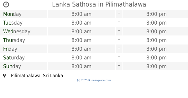
Lanka Sathosa
Pilimathalawa
Supermarket
read more
14.571 km
Seetha Super Market
A1, Pilimathalawa
Supermarket
read more
14.697 km
Keells Super- Kegalle
No.461 Kandy Road, Kegalle
Supermarket
read more
14.747 km
Cargills Food City
449/1 Kandy Road, Kegalla
Supermarket
read more
14.783 km
Cargills Food City Express - Eriyagama
NO:180, Colombo Road, Eriyagama
Supermarket
read more
14.826 km
Cost Co
Weligalla
Supermarket
read more
15.181 km
reliance
Kegalle
Supermarket
read more
15.72 km
Lanka Sathosa Kegalle
263, A1, Kegalle
Supermarket
read more
15.737 km
Cargills Food City - Nawalapitiya
51, Kandy Road, Nawalapitiya
Supermarket
read more
16.671 km
SMW Supermarket
Hector Kobbekaduwa Road
Supermarket
read more
16.814 km
Pathiraja Stores
Rambukkana
Supermarket
read more
17.097 km
MPCS - YATINUWARA
A1, Iriyagama
Supermarket
read more
17.58 km
Cargills Food City
Colombo Road
Supermarket
read more
17.742 km
Trystar Traders
Supermarket
read more
📑
all categories
Accounting
Administrative area level 1
Administrative area level 2
Airport
Amusement park
Aquarium
Art gallery
Atm
Bakery
Bank
Bar
Beauty salon
Bicycle store
Book store
Bowling alley
Bus station
Cafe
Campground
Car dealer
Car rental
Car repair
Car wash
Casino
Cemetery
Church
City hall
Clothing store
Colloquial area
Convenience store
Country
Courthouse
Dentist
Department store
Doctor
Electrician
Electronics store
Embassy
Finance
Fire station
Florist
Food
Funeral home
Furniture store
Gas station
General contractor
Grocery or supermarket
Gym
Hair care
Hardware store
Health
Hindu Temple
Home goods store
Hospital
Insurance agency
Intersection
Jewelry store
Laundry
Lawyer
Library
Light rail station
Liquor store
Local government office
Locality
Locksmith
Lodging
Meal delivery
Meal takeaway
Mosque
Movie rental
Movie theater
Moving company
Museum
Natural feature
Neighborhood
Night club
Painter
Park
Parking
Pet store
Pharmacy
Physiotherapist
Place of worship
Plumber
Point of interest
Police
Political
Post office
Premise
Real estate agency
Restaurant
Roofing contractor
Route
Rv park, camping
School
Shoe store
Shopping mall
Spa
Stadium
Storage
Store
Subpremise
Supermarket
Synagogue
Taxi stand
Train station
Transit station
Travel agency
University
Veterinary care
Zoo
administrative area level 3
sublocality level 1
sublocality level 2
↑