Cafe nearby Sanjana Cashew Products
Sri Lanka
Cafe nearby Sanjana Cashew Products
Sanjana Cashew Products
Nedagamuwa, Sri Lanka
contacts phone
:
+94 77 861 8721
Latitude:
7.1231987
, Longitude:
79.9493585
larger map & directions
read more
nearest Cafe
2.722 km
Gayan Tea Room
Ekala-Kotadeniyawa Road, Kotugoda
Cafe
read more
2.77 km
Janaka Hotel
Uggalboda Road, Paththanduwana
Cafe
read more
3.08 km
Varuni Snak Bar
Ekala-Kotadeniyawa Road
Cafe
read more
3.47 km
St.peters Shop
Udugampola
Cafe
read more
3.475 km
Nalin Bakers
Weediyawatta
Cafe
read more
3.509 km
Kristy Cool Spot
Udugampola Roundabout, Udugampola
Cafe
read more
3.6 km
Sisira Bakery
Udugampola
Cafe
read more
3.72 km
ඣානකතා Stores
Minuwangoda-Gampaha-Miriswatta Road, Udugampola
Cafe
read more
4.164 km
Kolakanda And Soup Shop
B288, Gampaha
Cafe
read more
4.164 km
Kolakanda And Soup Shop
Minuwangoda-Gampaha-Miriswatta Road, Gampaha
Cafe
read more
4.165 km
Shan's Cafe
Dharmaloka Mawatha, Ja-Ela
Cafe
read more
4.205 km
Mark Hotel
Ja Ela-Ekala-Gampaha-Yakkala Highway
Cafe
read more
4.254 km
Nilame stores
Samagi Mawatha
Cafe
read more
4.369 km
Chathu Cafe
Gampaha
Cafe
read more
4.649 km
P&S Bakers
Ja Ela-Ekala-Gampaha-Yakkala Highway, Ja-Ela
Cafe
read more
5.593 km
Dilus Hotel
Ja-Ela
Cafe
read more
5.754 km
Perera & Sons
112 Gampaha Fly Over, Gampaha
Cafe
read more
5.861 km
Sharas Cafe
Medagama 2, Gampaha
Cafe
read more
5.865 km
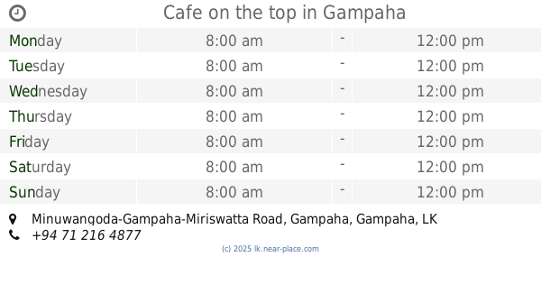
Cafe on the top
Minuwangoda-Gampaha-Miriswatta Road, Gampaha
Cafe
read more
5.911 km
Isuru Caters Pvt Ltd
No 6 Oruthota Road (next to Gampaha railway Station
Cafe
read more
5.938 km
Nimaka Foods
Bus stop road, Gampaha
Cafe
read more
5.968 km
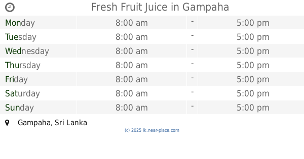
Fresh Fruit Juice
Gampaha
Cafe
read more
6.077 km
Herbel Hut
Gampaha-Moragoda Walkway, Gampaha
Cafe
read more
6.138 km
Cafe T-Breeze
No 32, Courts Road, Gampaha
Cafe
read more
6.184 km
Gampaha Court Canteen
Medagama 2, Gampaha
Cafe
read more
📑
all categories
Accounting
Administrative area level 1
Administrative area level 2
Airport
Amusement park
Aquarium
Art gallery
Atm
Bakery
Bank
Bar
Beauty salon
Bicycle store
Book store
Bowling alley
Bus station
Cafe
Campground
Car dealer
Car rental
Car repair
Car wash
Casino
Cemetery
Church
City hall
Clothing store
Colloquial area
Convenience store
Country
Courthouse
Dentist
Department store
Doctor
Electrician
Electronics store
Embassy
Finance
Fire station
Florist
Food
Funeral home
Furniture store
Gas station
General contractor
Grocery or supermarket
Gym
Hair care
Hardware store
Health
Hindu Temple
Home goods store
Hospital
Insurance agency
Intersection
Jewelry store
Laundry
Lawyer
Library
Light rail station
Liquor store
Local government office
Locality
Locksmith
Lodging
Meal delivery
Meal takeaway
Mosque
Movie rental
Movie theater
Moving company
Museum
Natural feature
Neighborhood
Night club
Painter
Park
Parking
Pet store
Pharmacy
Physiotherapist
Place of worship
Plumber
Point of interest
Police
Political
Post office
Premise
Real estate agency
Restaurant
Roofing contractor
Route
Rv park, camping
School
Shoe store
Shopping mall
Spa
Stadium
Storage
Store
Subpremise
Supermarket
Synagogue
Taxi stand
Train station
Transit station
Travel agency
University
Veterinary care
Zoo
administrative area level 3
sublocality level 1
sublocality level 2
↑